
Daily record high of 84° at BNA was broken today – we got all the way up to 87°. Late October or May? A strong SW wind has helped really get those temps up today – gusting to 20 mph at times. Winds should relax as we get closer to sunset.

Daily record high of 84° at BNA was broken today – we got all the way up to 87°. Late October or May? A strong SW wind has helped really get those temps up today – gusting to 20 mph at times. Winds should relax as we get closer to sunset.

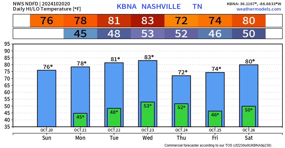
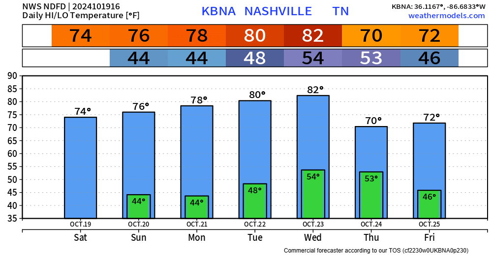
Before the cold front, record high temps will be possible on Friday. The daily record high is 84° and the current forecast is 86° – nearly 20° above average for this time of year.
Winds could get a little breezy Friday afternoon and evening, with gusts up to 20mph.

Still our only rain chance in the next 7 days is the potential for a sprinkle, maybe a quick shower Friday night thru Saturday morning.
“NBM has a slight chance pop for Friday night in our northern counties, but a shower appears possible area wide Friday night into Saturday per GFS/ECMWF.” – NWS Nashville AFD

Today is the 23rd consecutive day of no rain. That is no good.
The only chance of rain in the next week, and it’s not very promising, is Friday night into Saturday morning.
And by chance of rain, the current probability of seeing any measurable rainfall is ~10%. The odds are certainly against us, and at most it would be a quick sprinkle. Nothing of significance.

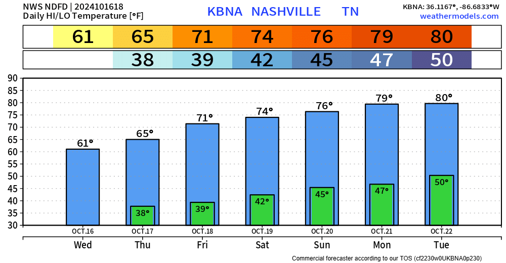
Seasonally warm temperatures expected throughout the week, with several days getting into the low 80s.
Still really no rain chances to talk about. The GFS and Euro ensembles think any rain chances hold off until late October/early November.
More of the same, warm afternoons, cool mornings. No rain. Boring weather is good!
We are at 3 weeks of dry weather, and while we could see a sprinkle on Wednesday, but likely not.
“No significant chance for rain is on the horizon until possibly Halloween or the first of November…” – NWS Nashville
Forecast is basically unchanged from yesterday. Warm afternoons, cool mornings and dry this weekend. Very Fall-like.
Mon – Wed will be a tad warm with high temps around 80°. Maybe a sprinkle Wednesday night as a cold front pushes thru our area, but likely nothing except a drop in temps.
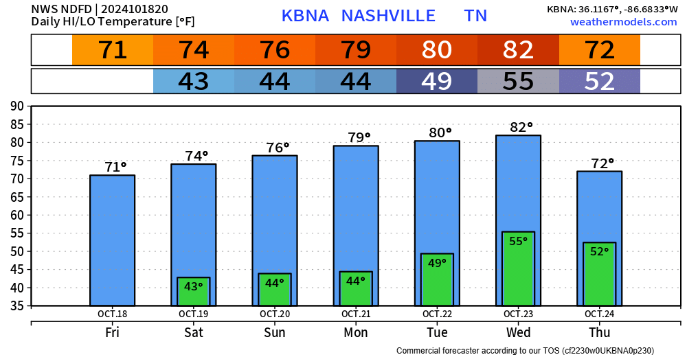

Great weekend weather. Highs in the 70s, nights will still be cool – but nothing abnormal for this time of the year.
Our average high temp for this time of the year is ~70°, and we’ll be above norm Saturday thru Wednesday, maybe reaching 80° a couple of days.
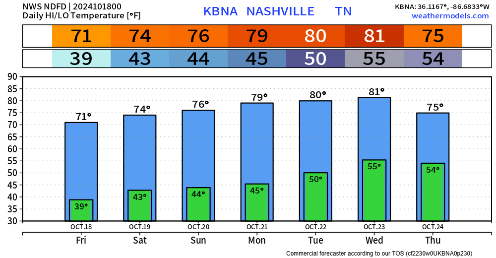
If you covered any plants last night, would be a safe call to leave them covered for tonight. The official low at BNA is 39°, but your backyard may get down into the mid 30s.
High temperatures return to the 70s starting tomorrow and stick around for the next 7 days, some days even pushing 80°.
Temperatures down into the 30s, clear skies and light winds will likely set us up for frost tonight. If you didn’t see any last night, you’ll have a better chance tonight.
If you are covering any plants tonight, you might as well leave them covered for Thursday night/Friday morning. While probably not as widespread, some patchy frost will be possible.
You must be logged in to post a comment.