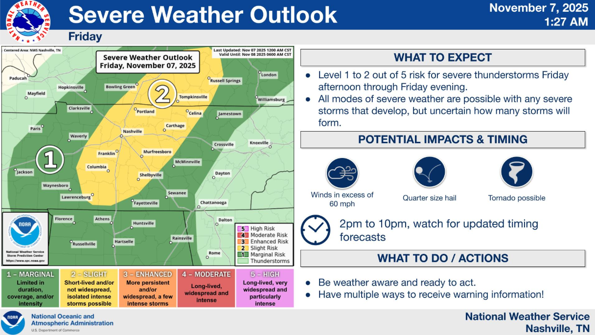
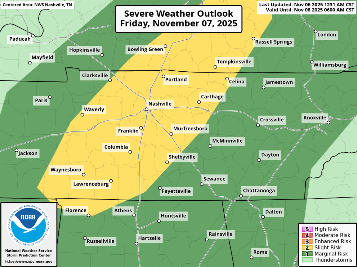
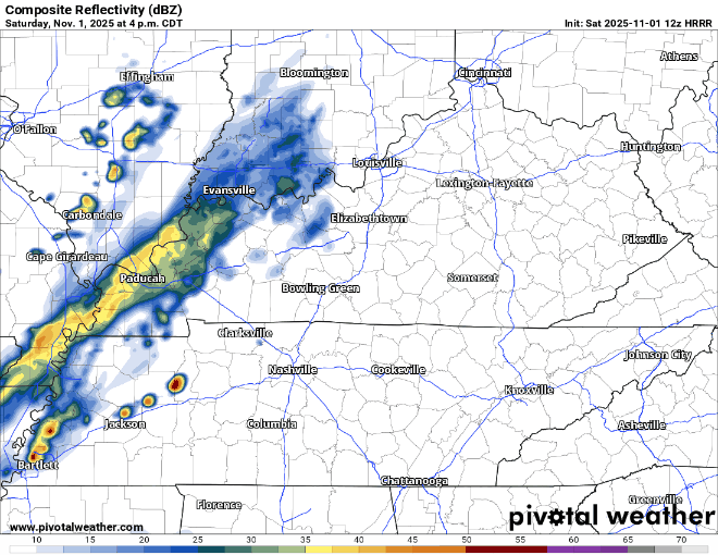
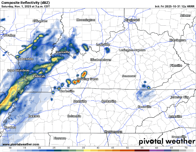
Snow To Continue Until This Evening, Travel Impacts Expected to Last Into the Weekend

Its Happening Ron Paul GIF

Well, it’s snowing.

Our Winter Storm Warning is set to expire at 9p tonight.

“Additional snow and sleet accumulations between 1 and 3 inches, as well as a light glaze from ice south of I-40…” read more

Winter Storm Warning for Friday, 6-8″ of Snow Expected, Treacherous Travel Likely Friday

There’s been a few tweaks in the details for our upcoming snow tomorrow, but the overall forecast remains on track.

Headlines:

  • We’ll be under a Winter Storm Warning starting at 3a Friday
  • 6-8″ of snow is most likely, maybe a little more, maybe a little less
  • Road conditions will quickly deteriorate starting Friday morning
  • Travel impacts will last until at least Saturday

Data can still change! Stay tuned for the latest updates on all of our socials. We’ll also be hosting a YouTube Live at 8p tonight to answer all your questions, and to hopefully make some decent jokes. read more

Winter Storm Warning for 3-6″ of Snow Expected on Friday, Very Difficult Travel Conditions Expected Friday Continuing Into The Weekend

As we continue to get closer to the event, some details are being finetuned, but overall, the forecast is on track.

Headlines:

  • We are now under a Winter Storm Warning for most of Friday
  • 3-6″ of snow is expected, with 4-6″ most likely for us.
  • Travel conditions likely to quickly deteriorate starting Friday morning, and stay hazardous through the weekend.

Details still could change, stay connected for updates!

🕖 Timing

Overall, the timing remains the same. read more

Winter Storm Watch Friday, Major Travel Impacts Likely Starting Friday Morning Possibly Lasting Into The Weekend

Headlines:

  • A Winter Storm Watch is in effect from early Friday morning thru late Friday night.
  • This will likely soon be upgraded to a Winter Storm Warning due to confidence continuing to increase.
  • Major travel issues likely start Friday morning, lasting throughout the day.
  • 3-7″ of snow possible, 3-5″ most likely as of right now.

Let’s dive into the details. Forecast could change! Stay connected for updates.

⏰Timing

ETA of snow is expected sometime between 4a and 10a Friday, most likely around 7a Friday.

Snow will likely stick around for the majority of the day Friday. Snow should stop sometime Friday night; best guess right now would be 7-10p. read more

Snow Increasingly Likely Friday, Potential Travel Impacts Starting Early As Friday Morning

Although I am always hesitant with snowfall potential in our area, model guidance continues to point to us getting at least some snow on Friday. However, there’s still a good bit that still has to work itself out. read more

Cold Week Ahead, Looking at the Snow Potential on Friday/Saturday

You may see a few flakes flying around over the next couple of days, but no accumulation is expected. There could be some slick spots on the roads tho – especially bridges and overpasses.

Before we talk about any of the winter weather stuff – it’s going to be downright cold this week. read more

Maybe a Dusting Monday, Winter Weather Possible Late This Week

Rain, heavy at times, will continue throughout the evening. No severe storm worries. You can check the radar anytime on our website here: Radar | Nashville Severe Weather Rain will end overnight as we catch some z’s. read more

Winter Weather Advisory for Davidson County; Light Freezing Rain Possible Sunday Morning, On/Off Rain Sunday Afternoon/Evening

A Saturday Evening update from our NWS added Davidson County to the Winter Weather Advisory that had previously been confined to counties north of us.

While impacts appear to be confined to Sunday morning, these impacts could cause car accidents or slip/fall injuries. Sidewalks, roads (particularly bridges and overpasses) may briefly become slick. Be prepared to take it slow on the roads Sunday morning. You may not encounter any ice, but better safe than sorry. read more

Light Freezing Rain Possible Sunday Morning N of I-40, Little to No Accumulation of Snow on Monday

Saturday looks dry, but cold. High temperatures may barely make it to 40°. Brrrr, but it’ll be even colder next week – this is just a little preview.

Now onto Sunday, we are still expecting a possible mix of precipitation, but right now impacts look very minimal to none. read more

Light Wintry Mix Possible Sunday Morning Before Changing to Rain

A clipper system is expected to move across the Ohio River Valley overnight tonight, and while most of the activity is expected to stay to our north but we could see a few showers Friday morning. HRRR model below gives an educated guess. Rest of Friday looks dry and cool with highs only in the mid 40s. read more