If you are trying to decide about getting something done outside either today or Sunday – I could not recommend today more.
That’s not entirely because today will be super nice, but because Sunday will be brutally cold.

If you are trying to decide about getting something done outside either today or Sunday – I could not recommend today more.
That’s not entirely because today will be super nice, but because Sunday will be brutally cold.
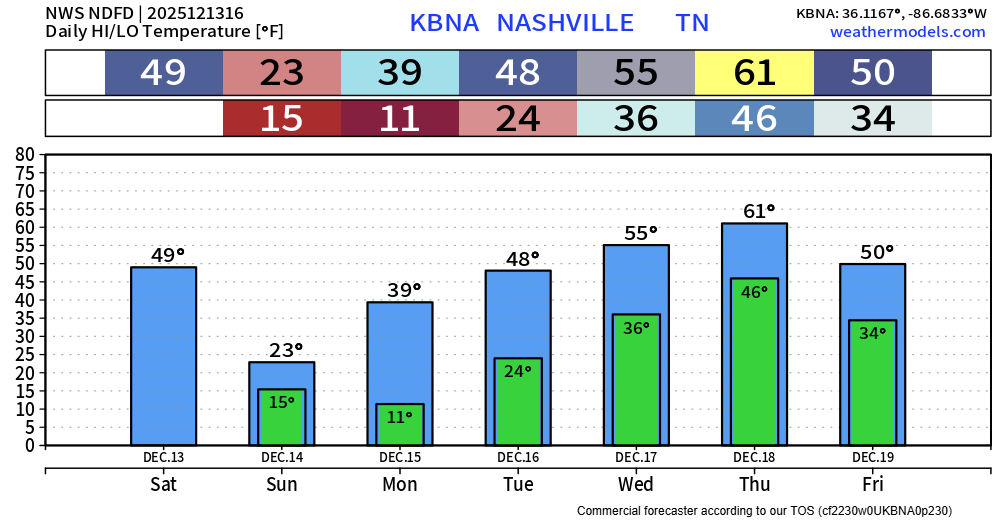
High temps in the mid 50s today will be slightly above our average high of 50°. Lots of sun.
Highs will be around 50° on Saturday. Out of the two weekend days, this will be the day to get stuff done outside if you need to.
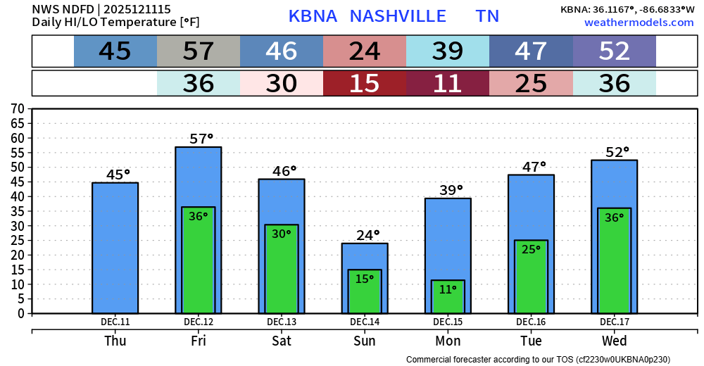
Today will be chilly with highs only reaching the mid 40s – which will be nice compared to what we deal with Sunday.
Friday will be the “warm” day out of the next 7, with highs in the upper 50s.


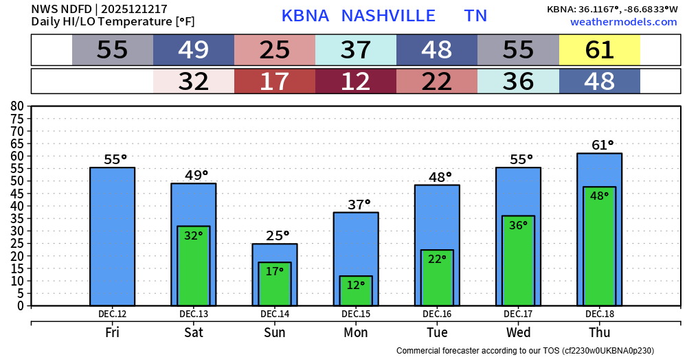
Our next weather system will approach Wednesday. It’ll be a cold front that’ll knock our temps back down for Thursday, but nothing extreme. Not even expecting precip with this cold front.
However, you will notice south winds pick up ahead of this front. Gusts to 30 mph possible tonight and into Wednesday. Strap down your outdoor decorations!

Endure today, and things will get better tomorrow. That applies to more than today’s weather, btw.


We were hoping for a high in the low 50s today, but these clouds are really really stubborn…and keeping us squarely in the mid 40s.
A cold front arrives tonight, bringing our next rain chances. Amounts will generally be a tenth of an inch or less. HRRR from 8 pm tonight – 8 am Monday.

While Winter doesn’t officially start until the 21st, we’re right in the middle of it meteorologically. I had my driveway concreted the other day, and we’re currently accessing our house by driving through this and through a field….so I’m as ready as anyone for some sun and warmer temps. If you see a mud-covered pickup truck with a NashSevere sticker driving around, wave. I’ll wave back.


Blerg conditions are met when temperatures are below 40 degrees, no snow, no sun. Officially, the forecast high temp is 41 at BNA. I dunno that we’ll get there. Blerg.
Temps hit 50 degrees for Saturday and Sunday ahead of our next system. 🎉

Light precipitation begins late this afternoon, continues until after midnight. We expect the margins to be razor thin with this event as to exactly which type of precip occurs where you are. Generally speaking, the chances for all rain and no impacts are highest in S Williamson Co, and the chances for a mostly sleet/snow mixture with temps reaching 32° or below are highest in N Davidson. A mix of sleet, snow and rain will likely exist in between and may go back and forth multiple times. Could even see some freezing rain mix in at times, especially in the higher elevations of W Williamson Co.
You must be logged in to post a comment.