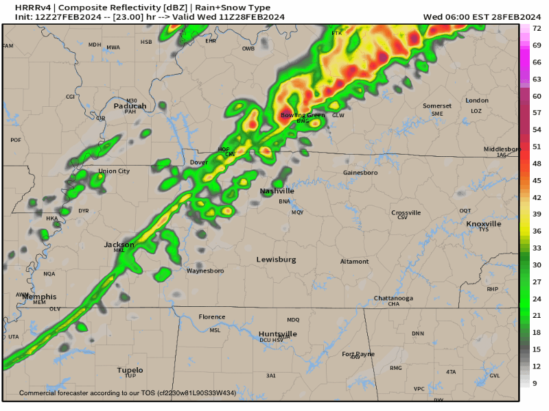
Storm line ETA 6-8 AM Weds morning. Not expecting severe weather BUT will monitor closely. Any little uptick in instability could create strong storms. Anxiety level low. HRRR model below. Very cold temps behind this line. Dress warm tomorrow. read more

Wind Advisory Thru Noon Wednesday, Rain + Maybe A Storm Wednesday AM

Another warm day despite the cloud cover.

Wind Advisory is in effect now thru noon Wednesday. Wind gusts up to 40 – 45 mph will be possible.

Early Wednesday morning, a line of rain/storms is expected to move thru. Severe weather is not expected, but a storm on the strong side cannot be ruled out. read more

Dirty cars likely caused by smoke and dusty particles trapped aloft and redirected to earth by early morning rains.

The muddy, dirty residue on your cars from the morning rain was caused by people who post “viral“ order of operations math on social media.

Tonight/Overnight, severe weather ingredients set up well away to our north. Tornadoes are a concern for the Ohio River Valley:

Local concern is currently low. What’s left of that system will weaken as it approaches us Wednesday early morning around 6 AM – 8 AM (rough ETA, for now). read more

South winds gusting to 40 MPH thru Weds AM. High today 77°, record for 2/27 is 80° set last year.

Weak storm line ETA 6-7 AM Weds. Severe unlikely.

Temps crash cold after that line. Dress for winter Weds. read more

Few thunderstorms not a concern this early morning / 438 AM

Wind Advisory Noon Tues - 6am Wed. Line of Rain/Storms Wednesday AM.

Beautiful day today, 3 degrees short of the record high of 79° at BNA.

Similar temperatures for Tuesday, but we have some non-thunderstorm winds and rain to deal with.

A Wind Advisory will go into effect starting noon Tuesday and go thru 6am Wednesday. Sustained winds around 20mph, with gusts up to 40mph will be possible. Secure any outdoor furniture and bring in those trash cans ASAP. read more

High at BNA got to 76º today. The record is 79º for this date.

New Wind Advisory. South winds around 20 mph with gusts up to 40 mph expected. Advisory begins noon Tuesday and ends 6 AM CST Wednesday.