
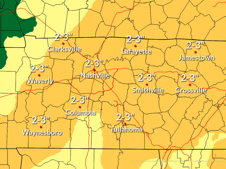
Forecast rain amounts have increased in the last 24 hours, with widespread 2-3 inch rainfall expected between Friday evening and Sunday evening.

Now that the leaves have fallen, this is a good time to check the drainage on your property and clear out any gutters/drains/culverts/ditches that are designed to carry water away. While the flood threat is low, clogged drains could create an issue.
Timing: On/Off sprinkles & showers (mostly off) begin late Friday evening, continuing Saturday. The vast majority of our rain appears to fall overnight Saturday into early Sunday morning.
Severe Threat: SPC has outlooked those W of I-65 for the possibility of damaging straight line winds Saturday night as our main rain/”storm” event arrives. The risk of said damaging winds is low and so is our anxiety level. The “best” storm ingredients will remain off to our SW. Subject to change. We’ll provide updates.

Snow: Yesterday’s note in the blog still applies. You may hear local mets discuss snow – they cover the plateau, too, so they have to mention it – there’s no compelling evidence for this system to bring us snow as the system departs Sunday.
Drought Update: Our drought is still a thing, although it has improved some. We’re now in Moderate/Severe Drought categories. This weekend’s rain should help things.
Temps: Some cold air will definitely blow through as our weekend system departs.

Quick References:
Weather changes constantly.
Follow @NashSevereWx on Twitter for any changes to this forecast.
Live coverage during tornado and severe thunderstorm warnings:

Look good.
Support the mission.

We are 100% community supported. No ads. No subscription fees. Keep it free for everyone.


Categories: Forecast Blogs (Legacy)
You must be logged in to post a comment.