

Rain and Storm chances return Sunday afternoon. Until then, sticky-uncomfortable humidity (dewpoints in the 60°s) with typical mid-July temps:
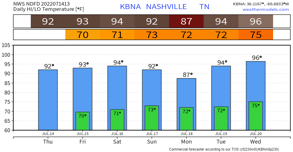
Humidity jumps up Sunday afternoon when The Wattery will resume. Place your bets on getting an isolated, scattered shower or thunderstorm overhead each afternoon Sunday through at least Weds. Lightning the hazard, not concerned about tornadoes.
It’s been at least 90° every day for the past 24 days. This is a Top 10 streak.
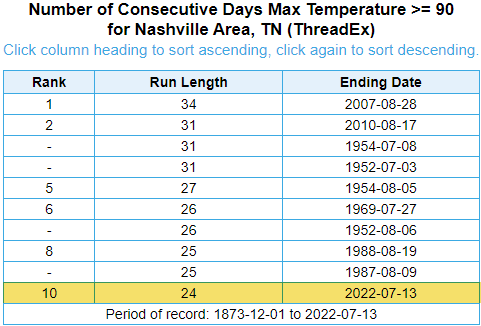
Today will be day 25. We should approach top 5 by the end of the weekend. The streak may snap Monday if a storm pops over the official temp site at BNA, or if it’s just super cloudy. It’ll be close. Monday’s high is 88°.
The Heat Index should settle in around 100° to 105° Tuesday-Wednesday afternoons as heat and humidity crank back up. Data is fuzzy at this range but Weds looks worst with a 97° high temp and 72° dewp, that’d be a 106° heat index. That may be an exaggeration, but if not, that combo would be among the hottest stretches this summer.
Quick References:
Weather changes constantly.
Follow @NashSevereWx on Twitter for any changes to this forecast.
Live coverage during tornado and severe thunderstorm warnings.

Look good.
Support the mission.

We are 100% community supported. No ads. No subscription fees. Keep it free for everyone.


Categories: Forecast Blogs (Legacy)
You must be logged in to post a comment.