

Temps drop today and rise only a bit tomorrow. Both below seasonal norms. No rain either day. Comfortable humidity.
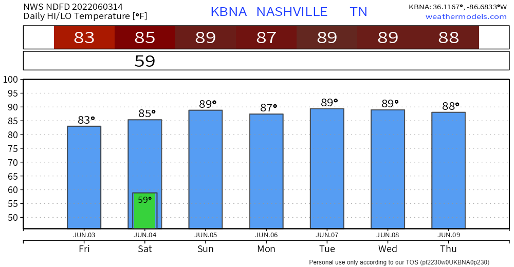
→Sunday things start unsettling. Dewpoints and temps start to rise at the surface while winds aloft shift and allow subtle little disturbances to pass overhead. This combo creates random rain and thunderstorm chances for mid-late afternoon through early evening. Rain at your location Sunday is unlikely but cannot be ruled out.
Few high res models are in range Sunday afternoon. Those show a few showers/storm freckling the region.
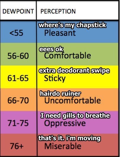
→Dewpoints climb into Stickyland Monday and jump to Uncomfortable Tuesday then stay there through the week.
→Karen Szn begins Monday. Low level humid air just waiting to be lifted and turned into rain and storms. Disturbances overhead. Individual cells just waiting to go off on a few unsuspecting people. The Karens will pop up and suddenly, randomly, be among us, the byproduct of a free society. We think that’ll be the story every day this week. Karens usually go off mid-late afternoon through early evening. A few Karens may contain lightning, strong winds, and may even be floody, but organized severe weather is not a concern.
Quick References:
Weather changes constantly.
Follow @NashSevereWx on Twitter for any changes to this forecast.
Live coverage during tornado and severe thunderstorm warnings:
Look good.
Support the mission.
We are 100% community supported. No ads. No subscription fees. Keep it free for everyone.
Categories: Forecast Blogs (Legacy)
You must be logged in to post a comment.