
Rain is expected Thursday morning. There’s a very low possibility of a tornado.
Storm Prediction Center just introduced a 2% probability of a tornado occurring within 25 miles of us overnight or in the morning. Expect a rainy morning commute with about 1" of rain. pic.twitter.com/xpXFdMMXry
— NashSevereWx (@NashSevereWx) November 1, 2018
We’ll be tweeting the event on Twitter @NashSevereWx. Not on Twitter, here’s our page for that.
Heavy Rainfall Expected Beginning After Midnight
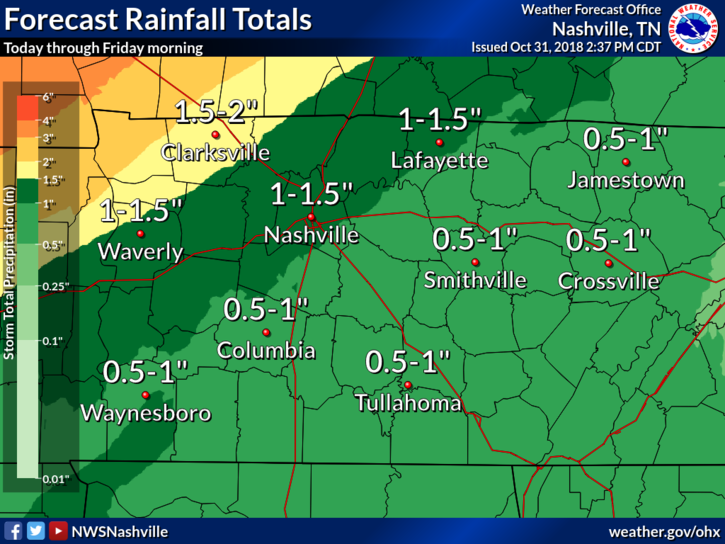
We have been advertising 2-4″ of rain through Thursday night for the past couple of days, but it is looking more like the 1″-1.5″ range now. All-in-all, flooding should not be a concern in Williamson or Davidson Counties; we will only have to watch for that to the northwest of Nashville.
Beyond Thursday
From NWS Nashville:
Heavier rains will exit Middle Tennessee Thursday evening and we’ll likely be left with cloudy/drizzly/cool conditions through a good portion of the day Friday. Sun is set to return Saturday and we’ll warm each day until Tuesday when it looks our next weather maker will move into the region. This is looking like another very dynamic system, so it will need to be monitored closely through this weekend.
Even the Storm Prediction Center is talking about this, noting if the Euro model solution turns out to be accurate, “a severe threat would be possible along a cold front in the Southeast Tuesday afternoon.” Confidence at this range, of course, is low, but I’m sure this may raise eyebrows for politicians.

Categories: Forecast Blogs (Legacy)
You must be logged in to post a comment.