
One week ago: “I sure wish it would rain. It never rains. We need rain really bad. My garden is dying. When is it going to rain?”
Today: “Enough rain already. Everything is flooded. Make it go away. Please stop. STAAAAAHHHHHP!”— NWS Nashville (@NWSNashville) June 28, 2018
NWS Nashville sums it up perfectly! Pick a side!
The weather pattern that brought strong and severe storms from the NW this week has ended (for now).
We now return to your regularly scheduled typical summertime chances of pop-up, random, heat/humidity-driven rain and thunderstorms.
Today & This Weekend
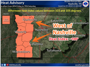
The National Weather Service has issued a Heat Advisory for areas west of Nashville. That means the heat index is supposed to be 105º. We shouldn’t get that hot here, but it’ll be close. Heat indices will be near 100º today in Nashville, higher to the west prompting the Heat Advisory.
High pressure is building to our northwest this morning – giving way to the heat and humidity today. We could see some isolated redevelopment of storms later today, however, it will not be as widespread due to sinking air associated with the high-pressure.
Saturday will be a degree or two warmer than today. Overall, it will still feel hot and humid, with a heat index around 103º.
Few more clouds Sunday with a slightly higher chance of afternoon pop-up storms. With the extra shade, the heat index should stay at or below 100º.
Monday
A convergence of two large weather systems will drive up rain chances into “notable” territory.
Timing and locations are uncertain with Monday because both aspects are heavily dependent on the convergence point. We are watching.

Temperatures through next week appear to be staying in the 90º range for highs and the 70º range for lows.
Check back here for updated forecasts or @NashSevereWx on Twitter. Not on Twitter? We have you covered.

Categories: Forecast Blogs (Legacy)
You must be logged in to post a comment.