
Scattered Showers Today
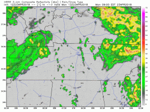
Good morning Nashville! Low pressure is going to move across the state of Tennessee today. This morning, it was centered in the Memphis area and will move east as the day progresses. You can see it in the HRRR 3km simulated radar this morning; it is able to be depicted by the center of rotation of the showers today. All in all, looking at on and off rain for Williamson and Davidson Counties this morning. High of 68º expected today. A thunderstorm or two is not ruled out.
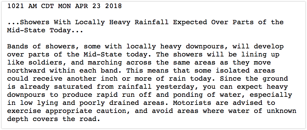
Also, heavy rain is also a possibility throughout the day. NWS sent out this special weather statement.
Tuesday Through Friday
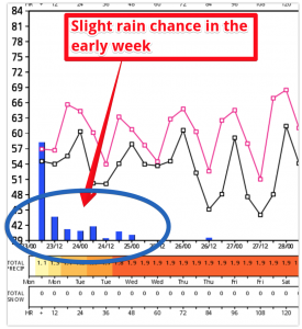
Models are a bit all over the place this week as a cold front approaches from the northwest. The European model (displayed above) shows a drier solution whereas the American (GFS) model has the cold front being a little potent. For now, know that there is a slight chance of rain every day this week and we will hopefully have a better handle on the solution by tomorrow.
High temperatures will be in the upper 60s each day with morning temperatures in the upper 40s and lower 50s.
Next Weekend
We are still on track for little in the way of rain for next weekend! The models are not in agreement quite yet on the solution, however, the forecast looks to be trending drier than previously thought.
Marathoners should check back frequently; this forecast will continue to yo-yo. The Euro model still has light rain on Friday, with the rain gone before race time. There remains no indication of a race downpour, and no reason to think it’ll be scorcher. All in all, a pretty good outlook: mid/upper 40°s by race time, warming only to low 60°s when it’s over.

Keep checking back to NashSevereWeather for the changes in this uncertain forecast!

Categories: Forecast Blogs (Legacy)
You must be logged in to post a comment.