
A Relatively Boring and Way Too Hot Forecast Ahead
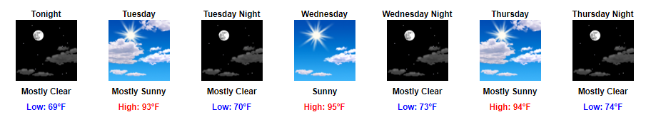
We’ve officially reached the not-so fun part of summer this week. Highs will stay in the 90s with our dew point temps in the mid-60s to start the week and low-70s to end the week.
https://giphy.com/gifs/reaction-imgfave-RddAJiGxTPQFa
Why you might ask? We will have a high pressure located over our area throughout this week, which will keep out those afternoon rain chances. While some of you may celebrate, without these pop-up chances, our temps will be able to continue to climb until the end of the week.
https://giphy.com/gifs/hot-warm-sweating-l46CzqlTNVbhQrpFC
With our temps and dew point temps being this high, it will feel oppressive outside, especially during the second half of the week. If you need to be outside for long periods of time this week, the first half of the week appears to be the best time to do so.
Heat index values (what it will feel like outside) will be in the 100° to 105° range starting Thursday and lasting through Saturday.
https://giphy.com/gifs/gPTTdOsD3lEQw
For this reason, our local NWS office issued a Special Weather Statement today concerning the heat near the end of the week.
The first significant heat wave of the summer arrives late this week and continues over the weekend. Special Wx Statement from @NWSNashville pic.twitter.com/53OIhNkpQY
— NashSevereWx (@NashSevereWx) July 17, 2017
In terms of relief, there just does not appear to be a whole lot this week. Next chance of rain doesn’t appear to be until maybe the beginning of next week. However, that is still in la la land forecast. Until then, stay cool and hydrated.
https://giphy.com/gifs/stanaustralia-friends-26xBNnrR0VknSQo9i

Categories: Forecast Blogs (Legacy)
You must be logged in to post a comment.