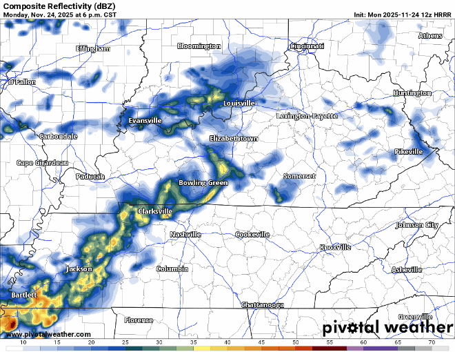
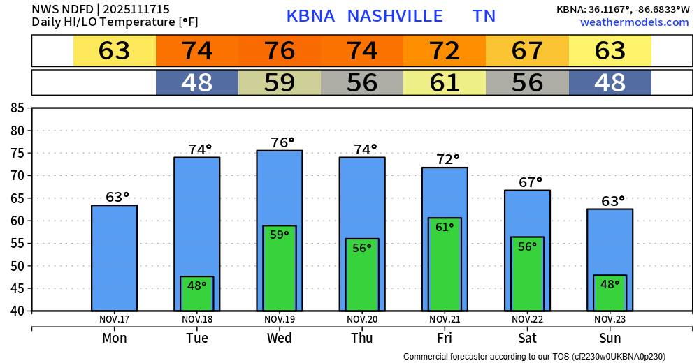
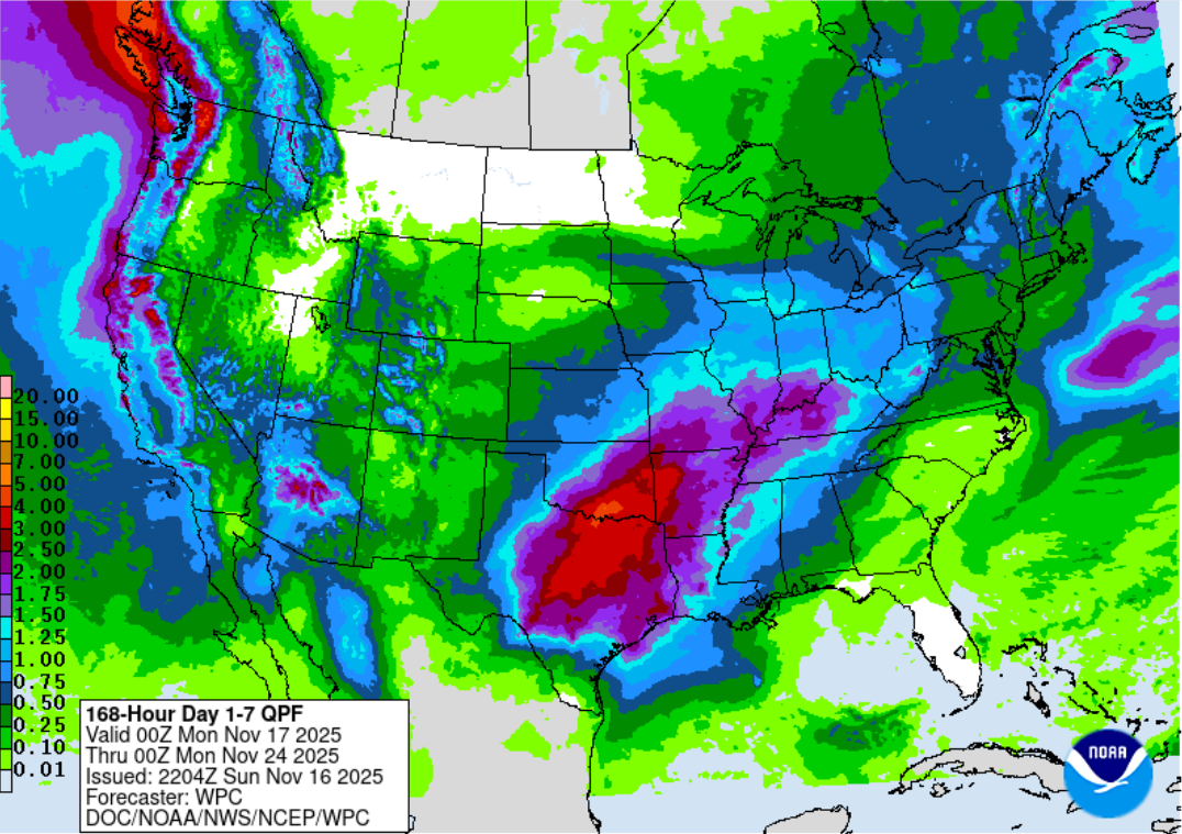
Rain Departing By Thanksgiving Morning, Several Hard Freezes This Weekend

Showers will continue to move across the area thru the overnight hours, just some showers, although a few could be on the heavier side. No severe or winter weather concerns. HRRR model gives its best guess below. read more

Wednesday Evening Showers, Mostly Dry Thanksgiving, First Shot This Season at sNOw Saturday Night

The busiest travel day of the year (Wednesday) will be dry until the evening, when some light showers move thru. HRRR model shown below loops from Wednesday evening – Thanksgiving morning.

The HRRR, and most other models have come to the conclusion that besides maybe a few quick showers during the morning, Thanksgiving Day looks dry. Good news for all the Turkey Trots, backyard football and turkey frying. read more

Showers This Evening, Thanksgiving Trending Drier(?), Cold Air Later This Week

Highlights:

  • some showers (maybe a rumble of thunder) this afternoon & evening
  • Wednesday evening/night looks wet while Thanksgiving Day is trending drier
  • coldest air so far this Fall arrives late this week

Some ongoing (as of 4:30p) drizzle and showers will continue throughout the evening. HRRR gives a guess:

There may be just enough instability to squeeze out a rumble of thunder or two, but generally speaking, most of the activity should be light. No worries. read more

Quick Showers Monday Evening, Rainy Wednesday PM - Thanksgiving Possible

Monday will be our last warm day we have for the foreseeable future with highs getting into the upper 60s.

Light showers are expected to move thru the area Monday afternoon + evening, mostly evening. Not expected to be a big deal. read more

Getting Close to Freezing Tonight, Showers Monday Evening, Rainy Wednesday/Thanksgiving Possible

Another cold night ahead of us, some places will possibly get below freezing.

A jacket will be needed for any plans Sunday morning, but temps will recover very nicely with highs getting into the mid 60s by the afternoon. Highs Monday will get close to 70°. Looks like that’ll be our warmest day we have for a while. read more

Colder Weather Pattern Here (Besides Sunday + Monday), Wet Middle of Next Week

Saturday morning & Sunday morning will both be cold with temps in the low 30s. Areas outside of downtown Nashville will have a better chance at getting close to freezing, BNA unlikely to reach 32°. read more

Coldest Temps So Far This Season Expected Over the Next Couple of Nights, Wet Thanksgiving?

Several cold nights/mornings are ahead of us.

Friday morning, Saturday morning and Sunday morning we’ll be waking up to temps in the low to mid 30s. Friday night/Saturday morning looks like our “best” chance to hit the freezing mark, especially in more rural areas. read more

Wind Chills Around Freezing Next Several Mornings

Wind gusts up to 20 – 30 mph have been common today, and will continue to be thru Friday as cooler/drier air is ushered in.

Our next several mornings will be the coldest of the season thus far.

Thursday 7a Temp/Wind Chill: 38°/31° read more

Colder & Drier Air On The Way, (Too?) Early Look at Thanksgiving

Maybe some occasional mist throughout the evening, but the majority of the rain is gone.

As of 5:45p, dewpoints are in the low 60s across the area, this time tomorrow they will be in the low 30s.

Wind gusts from the NW up to 30 mph (possible Wednesday – Friday during the day) will aid in getting this much colder and drier air mass into our area. read more

Rain Tuesday Morning, Flirting with Freezing Late This Week

BNA managed to climb all the way up to 78°, just two degrees shy of tying the daily record high of 80° set back in 1985.

Tuesday will still be warm, but we’ll have some showers in the AM.

HRRR model shows: read more