
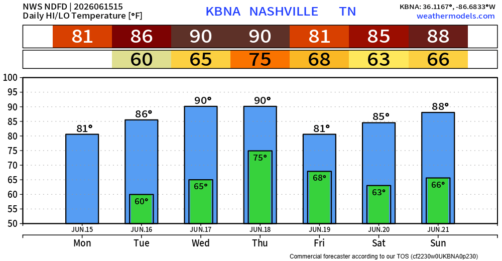
Hard to get nicer weather in the middle of June. Today and Tuesday will both have below-average temperatures paired with dewpoints in the upper 40s to mid 50s.

Plenty of sun and dry. Make any excuse you can to get outside.
Wednesday, both temperatures and dewpoints creep back up. Highs near 90° with dewpoints returning to the 60s – not as comfortable. Very low (~10%) chance of an afternoon popup, but majority of us will stay dry.
Next notable system will arrive Thursday as a cold front approaches, along with plenty of moisture streaming in from the south.
From Thursday afternoon thru Friday morning, we’ll be dealing with medium to high rain/storm chances. Although we are not currently outlooked for any severe weather, some strong storms will be possible.
We’ll also likely get some healthy rainfall totals from this as well, with anywhere from 1-3″ currently expected.
Things will evolve throughout the week. When details become clearer, we’ll share them and get into the specifics.
For now, Friday PM thru Saturday look dry with additional rain/storm chances returning Sunday.
Categories: Featured Blog