
In this blog: Freezing 🧊 Fire 🔥 Rain/Storms ⛈. Deets….
Near freezing around sunrise Tue. Warming up this week.
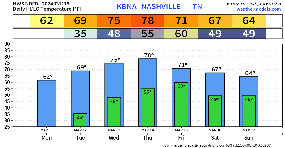
These temps 15-17 degrees above normal. Not hot enough to break records.
Fire Weather. Meh. Worth mentioning I suppose.
The only thing to note in the short term portion of the forecast is today`s relative humidity values, which will be running in the 20s this afternoon. While these are low, the recent rains and light winds should mitigate any fire weather concerns today.
NWS-Nashville Forecast Discussion 3/11/24
Rain/Storms Friday. ETA fuzzy, best guess most of it falls Friday morning (Euro model below).
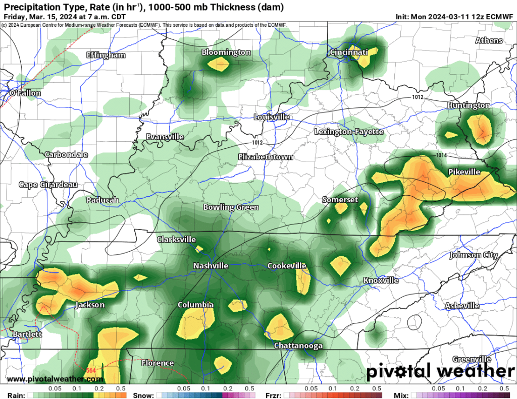
Rain could stretch into Friday afternoon. Still meh.
Severe unlikely. Storm Prediction Center: “predictability too low” suggesting data is inconclusive but the sense is cloud cover, timing, instability will conspire to keep storms behaving.
Experts below, followed by a translation:
This cold front is expected to continue eastward/southeastward across the TN Valley and Southeast on D5/Friday. Showers and thunderstorms are possible, but limited heating and scant buoyancy should keep the severe potential low.
Storm Prediction Center 3/11/24
[F]orecast soundings are mostly benign. However, I would argue that they`re worth watching, even first thing Friday morning. They`re not great (if I could put great in italics, I would [We can, and did, italicize!]), but a few hundred J/Kg left over from Thursday`s warm temperatures, dew points in the low 60s and some hodograph curvature (at least in our southwest counties) is worth keeping an eye on over the next couple of days. At a minimum, showers and thunderstorms will be abundant during the day Friday. Current QPF values are coming in between 1 and 2 inches.
NWS-Nashville Forecast Discussion 3/11/24
Translation:
- If the models are right, no severe weather Friday.
- This may change.
- Check back tomorrow and thru the week.
- Anxiety level: near zero 👍🏽.
Rain break Saturday, then another rain/thunder event possible Sunday. Some models paint an additional 1″ Sunday bringing cumulative Friday-Sunday rain to 3″ and 4″ somewhere in Middle TN. Minor, usual spot flooding is within the range of possibilities. Looks meh, but it’s March and worth watching.
Categories: Featured Blog