
Tonight
Tonight we have been outlooked with a 5% chance of damaging straight-line winds within 25 miles.
HRRR has been back and forth about tonight. Earlier runs showed a cluster of storms moving in around 8 or 9. Now, thinks we stay dry.
*Models are not perfect, and it could flip right back.* Outdoor goers, fair goers, need to stay connected tonight. Keep an eye on your fav radar app, or we have one on our website right here: nashvillesevereweather.com/radar
Sunday/Monday

Sunday and Monday we have been outlooked with a:
- 15% chance of damaging straight-line winds within 25 miles
- 5% chance of severe hail within 25 miles
- we are not outlooked for tornadoes
Sunday during the day looks okay. Maybe a few scattered showers/storms, but these wouldn’t be the main event.
Most of our activity looks to be Monday morning.
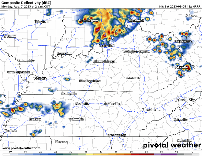
HRRR model (above) shows a cluster of storms moving in around sunrise Monday. These would carry a chance of damaging straight-line winds and hail. Overall confidence in this is still fairly low, so be sure to stay connected.
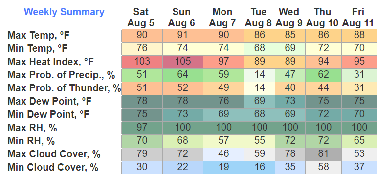
Besides the rain/storm chances, heat index values up to 105° are possible Sunday. The shade and water will be your friend.
Tuesday will have lower rain chances before they pick right back up Wednesday and Thursday.
Total precip the next 7 days looks to amount to around 2-3 inches. Should be spread out enough to avoid any flooding problems.
Quick References:
Weather changes constantly.
Follow @NashSevereWx on Twitter for any changes to this forecast.
Live coverage during tornado and severe thunderstorm warnings:

Look good.
Support the mission.

We are 100% community supported. No ads. No subscription fees. Keep it free for everyone.


Categories: Forecast Blogs (Legacy)
You must be logged in to post a comment.