
Storms thankfully missed us to the south today, leaving us with a dry evening.
Monday AM
We’ve been outlooked with a
- 15% chance of damaging (58mph+) straight-line winds within 25 miles
- 5% chance of severe (1″+) hail within 25 miles
- we are not included in any tornado probabilites
Tomorrow will be a conditional threat AKA there are more “ifs” than normal.
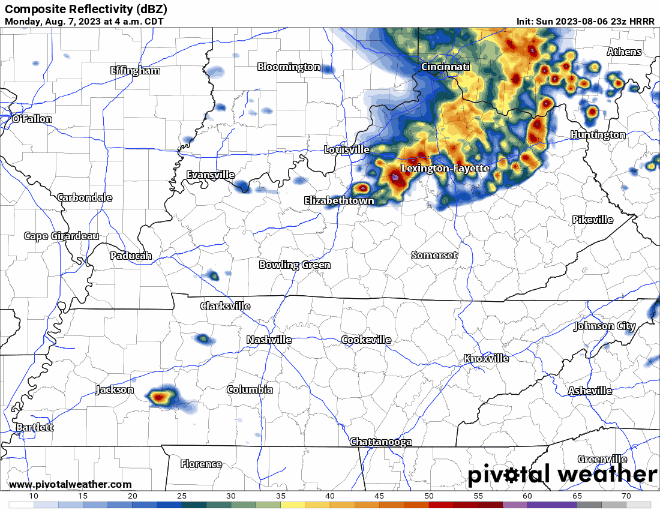
The latest HRRR model (above) has the storms forming on top of us Monday morning. Where these storms form will be very important.
Storms form to our west = more time for storms to strengthen, you may see storms reach severe criteria
Storms form on top of us = storms, likely showers at the time, do not have much time to strengthen, lesser chance of us seeing any severe
Storms form to our east = we stay dry and see nada.
Which one of these scenarios do we see? I wish I knew. Earlier runs of the HRRR showed the storms forming to our west.
Those commuting to school, work, or wherever tomorrow AM need to stay connected. We’ll be tweeting updates as needed.
Monday PM looks dry, although if we do see heavy rain, outdoor rollyball sports may be unplayable.
Tuesday looks like we get a break from precip before chances return Wednesday and stick around the rest of the week.
Right now looks likes severe wx chances Wednesday stay to our west. We’ll keep an eye on it.
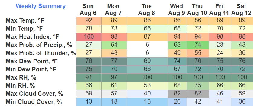
Rain/storm chances keep our temps at a reasonable level, mid to upper 80’s basically all week.
Quick References:
Weather changes constantly.
Follow @NashSevereWx on Twitter for any changes to this forecast.
Live coverage during tornado and severe thunderstorm warnings:

Look good.
Support the mission.

We are 100% community supported. No ads. No subscription fees. Keep it free for everyone.


Categories: Forecast Blogs (Legacy)
You must be logged in to post a comment.