
Today will be quite nice, seasonal temps, no rain besides for maybe a drizzle this morning. Sun should peak out later.
Tomorrow we turn our attention to a system that we’ve been watching for a while.
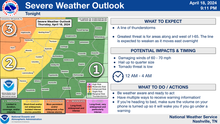
The Storm Prediction Center has outlooked our two counties with a
- 5% chance of a tornado within 25 miles
- 15% chance of both severe hail (1″+) and damaging straight line winds (58mph+) within 25 miles
- 5-15% chance of flash flooding within 25 miles
For now, the timeframe of severe weather looks to be from 3pm Tuesday – 3am Wednesday. By tomorrow morning I believe we should be able to nail down the timeframe a little more.
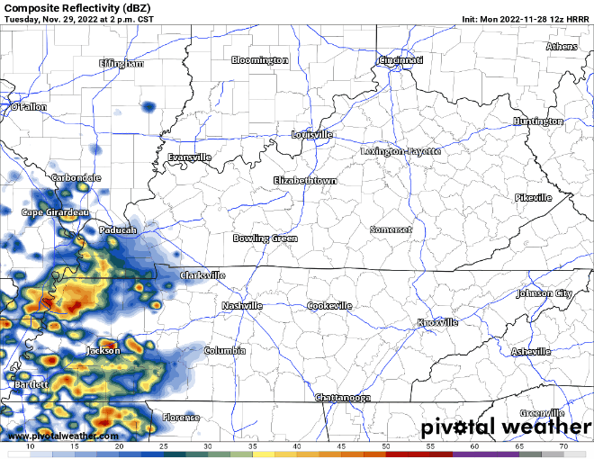
The HRRR model above shows not a line of storms, but more several rounds of scattered storms. Any of the storms have the possibility to be severe, but again I think tomorrow we’ll know a better timeframe of the strongest storm potential.
This is our fairly common high shear, low CAPE (storm fuel) setup.
There is no cause for panic, simply more of a cause for preparation. Here is a refresher on Watch vs. Warning and what to do if you are under a Tornado Warning. Finally, the threat of severe weather will linger into the night. Have a way to wake up if you are under a warning, such as a wake-me-up app and a NOAA weather radio. And as always we’ll be tweeting updates today and tomorrow as needed.
Rain should move out before AM rush hour Wednesday. Rainfall totals look to be around 0.5″ – 1.5″, which will help the drought.
Next rain chance will be Friday night/Saturday. More details in the following days.
Quick References:
Weather changes constantly.
Follow @NashSevereWx on Twitter for any changes to this forecast.
Live coverage during tornado and severe thunderstorm warnings.

Look good.
Support the mission.

We are 100% community supported. No ads. No subscription fees. Keep it free for everyone.


Categories: Forecast Blogs (Legacy)
You must be logged in to post a comment.