

A north wind kept us cool yesterday. Today we warm up into the low 70s and we’ll see very little cloud cover. Clouds begin building in on Saturday around noon. After that, our weather takes a bit of a turn.
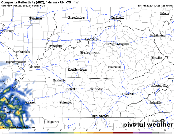
If you have plan Saturday, try to get them done during the day. Saturday night brings rain after dinner and possibly thunder overnight. No severe weather is forecasted. The 12z run of the HRRR below shows rain to our SW at. That rain moves NE. I’m not sold on the timing, light rain could get here as early as 8pm Saturday. There won’t be any frog stranglers in this system, but individual rain totals will be higher for some. The gif below begins at 5 PM and progresses in 1 hr increments.
Rain sticks around through most of the day Sunday. This won’t be the drought buster we need, but it will help. In total through Sunday night we can expect between .5″-1″ of rain. The GFS QPF has backed off of it’s totals a few tenths of an inch from yesterday.

Monday has more rain forecasted today than the last couple of days but I’m not ready to call it a rainy evening.

If you’re trying to prepare, plan on the chance for light and scattered showers. We don’t expect any weather to cause you to change plans.
Beyond Monday… There might be a chance for a little rain mid week, but most of the week looks dry.
Quick References:
Weather changes constantly.
Follow @NashSevereWx on Twitter for any changes to this forecast.
Live coverage during tornado and severe thunderstorm warnings.

Look good.
Support the mission.

We are 100% community supported. No ads. No subscription fees. Keep it free for everyone.


Categories: Forecast Blogs (Legacy)
You must be logged in to post a comment.