

Beautiful Wednesday Ahead
Warmer temps + sunny skies + a nice breeze = a beautiful day!
We saw some patchy fog this morning, especially around bodies of water. With temperatures warming up through the morning hours, it has since dissipated.

(Here’s some cool satellite imagery from this morning where you can see the fog dissipating!)
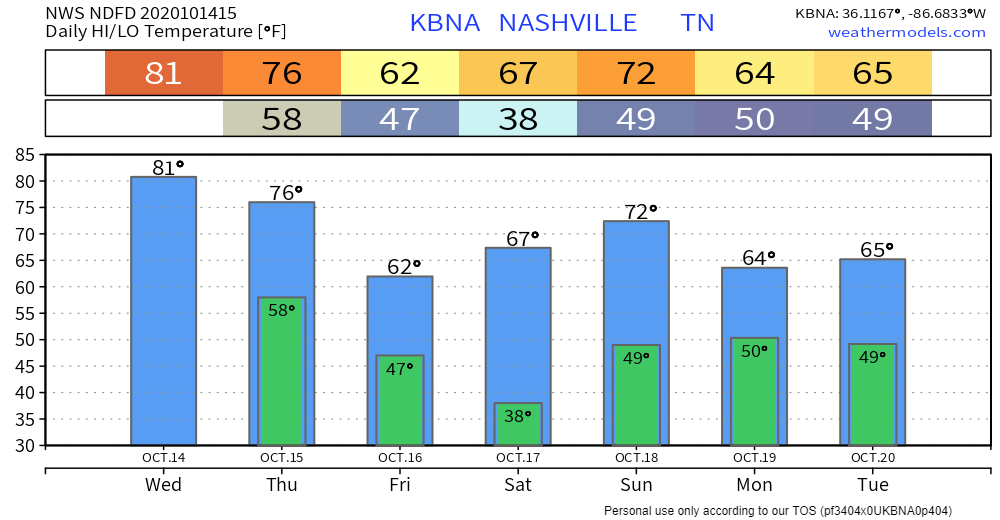
We’ll be seeing plenty of sun and clear skies today! Highs will get up near 81° this afternoon with a light south wind.
Clear conditions will continue into the overnight hours, with lows near 58°.
Another Cold Front Coming Thursday Night
We’ll see clear conditions throughout the afternoon with highs getting into the mid to upper 70s.
The front will be moving through late Thursday.
Although models don’t look very impressive, there is a chance of a couple showers popping up Thursday night into early Friday morning.
14°
That’s the temperature difference between Thursday and Friday.

Showers should be exiting the region by 1 pm Friday, giving way to sunny skies and high temps in the low to mid 60s.
For those Friday Night Lights, you may want to grab that blanket or jacket on your way out the door. Clear conditions will continue into the overnight hours, but it will be chilly. By 7 pm, temps will be dipping into the lower 50s.
Frost Possible Saturday Morning
Lows Friday night will get into the upper 30s, giving us a chance of seeing some frost Saturday morning.

Aside from possible frost, we’ll still have the possibility of seeing some patchy fog, especially around bodies of water.
Temps will climb back into the upper 60s and low 70s for the weekend.

Categories: Forecast Blogs (Legacy)
You must be logged in to post a comment.