
Current Radar
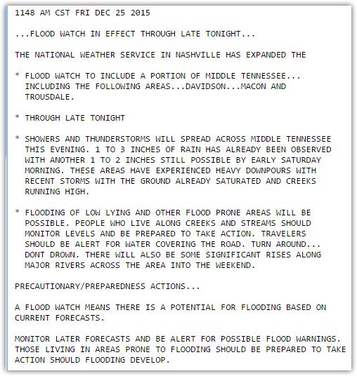
For that reason, the Areal Flood Watch now in effect for Davidson and Williamson Counties will continue. Here’s the official text of the Watch:
As the front comes back north, we should see some rain, but model guidance hasn’t been much/any help to determine when or how much. Not looking for much more rain from this, but we certainly aren’t dry.
The Weekend – Warm & Humid, But Not So Wet
High temps will likely break records. Temps should be 25° to 30° above normal. We’re looking for 76° Saturday and 77° Sunday.
The bulk of the rain should end Saturday morning as the front lifts north of us.The rain will settle off to our west and northwest, and — we think now — the rain should stay away for most of the weekend.
Too soon to draw conclusions about a Titans game rainout. GFS model has the rain holding off until later Sunday. pic.twitter.com/EolbfIi1Yk
— NashSevereWx (@NashSevereWx) December 25, 2015
Rain holding off until AFTER the Titans game is now the forecast.
The Next Storm System?
Rain will return Monday.
We may see thunderstorms, but right now severe weather looks like it’ll be far off to our west and southwest. It appears the system will occlude for us, meaning it’ll spread a lot of cooler air beneath the warmer air. You need the opposite environment to cause strong/severe storms. It’ll still need to be watched, but right now we aren’t worried about it.
When the rain moves in, seasonal temperatures will return!

This website supplements @NashSevereWx on Twitter, which you can find here.
Categories: Forecast Blogs (Legacy)