
Current Radar
A Severe Thunderstorm Watch is in effect until 7 PM tonight.
Remember, a Watch means conditions are favorable for severe weather, so be prepared. A Warning (which will not be posted to this website) means severe weather is occurring/imminent, so take
Here is the probability table:
The above probabilities are for the entire Watch area, including but not exclusive to us.
As you can see, damaging thunderstorm winds are the biggest concern, followed closely by hail. The probability of a tornado is small, but not zero. Storms are already gathering to our west and will begin to impact us around mid to late afternoon.
Follow multiple reliable weather sources. You can get additional information from us @NashSevereWx on Twitter.
Update 9:28 AM ————————————
Today – Thunderstorms; Severe Weather Possible this Afternoon into the Evening High: 88°
Today will be mostly cloudy, and humid with gusty southwesterly winds.
Storms are gathering to our west and northwest, and will move into today. We will see off and on rain/thunderstorms around mid-day.
The main event is expected later today.
Our area is included in a slight risk for severe weather this afternoon into the evening.
The main threats this afternoon and evening will be damaging straight line winds, hail, locally heavy rainfall, and frequent lightning.

There is a 15% probability of damaging wind thunderstorms and hail within 25 miles of an area included in the shaded yellow.
The HRRR model shows pop up showers and thunderstorms before the main line of thunderstorms sweeps through this afternoon into the evening. Models ETA for the main, potentially strong/severe, line of storms will be 5:00PM – 8:00 PM. Keep the umbrella handy all day today and be careful on roadways!

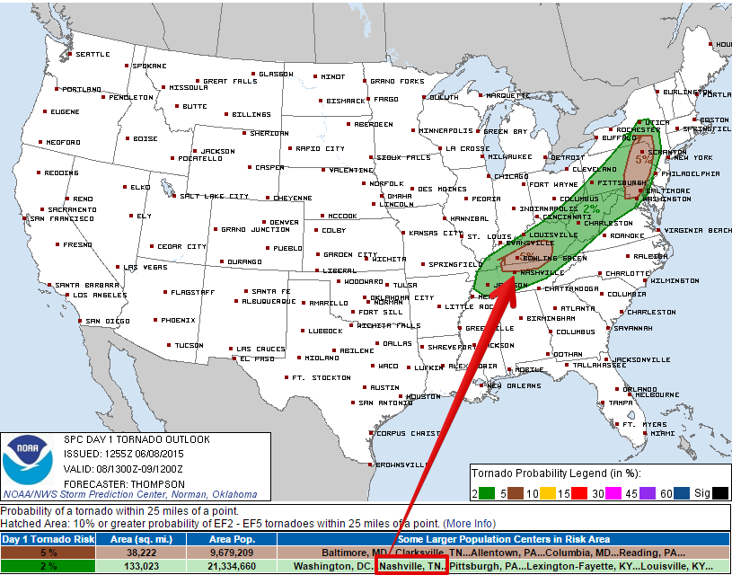
The tornado threat is pretty small. The probability of a tornado happening within 25 miles of us is only 2% (it’s 5% just north of us).
The QPF shows that our area will get up to 1″ of rain with locally heavier amounts of rain above 1″ within 24 hours.


Follow along on Twitter @NashSevereWx and turn on your favorite local meteorologists on TV during the day. No warnings will be posted to this website — follow along @NashSevereWx for updated and fresh info.
Tuesday – Slight Chance of Thunderstorms, Then Clearing in the Afternoon Waking Up: 67° H: 89°
Remnants of showers and thunderstorms can linger in the morning hours. The good news is there will be clearing with partly cloudy skies in the afternoon and evening.
Wednesday – Sunny & Very Warm Waking Up: 67° H: 91°
Stay hydrated! It will be humid and very warm on Wednesday with lots of sunshine!
Extended: Rain chances return later in the week…

This website supplements @NashSevereWx on Twitter, which you can find here.
Categories: Forecast Blogs (Legacy)
You must be logged in to post a comment.