
April postcards from Old Man Winter are common, but this May postcard has been waaaay out of bounds.
That said, you’ll like what we have to say about the rest of the day.
Today
At 11am the rain rope (“rain shield”) was sitting along I-65 and very, very slowly moving east at around 15 mph. It’s also way too chilly for May: 46 at 11am.
Right now the rain clearing has already started in western parts of Williamson Co., and will very slowly move east. It may be another hour before downtown clears, and not till around 2 PM for both Williamson and Davidson Co. to be clear completely.
The good news is the afternoon is looking better, with the main shield of rain finally moving east, but only after it dumped about 1″ of rain so far. It’s becoming very hard to predict when the rain will move out today, because there is so much disagreement between the models (What’s new?).
Water Vapor image (the amount of “wet” in the air) shows a dry slot of air (burnt orange color) moving in right behind all this rain:

So once the rain does move out we will be dry for at least a few hours, if not longer.
Visible satellite is showing clear skies behind this rain. So we may get to see the sun:

Totals
Here are the totals from around the area through 10 AM:

This may seem like a lot of rain but it’s well below the 2″ we expected today. Keep in mind it is still raining and that number will go up a bit more.
Sunday
Loop of High-Res NAM Saturday 10 AM – Sunday 1 PM:
We could remain rain free until Sunday afternoon with a high of 63 and with more scattered light showers picking up across the are from the “cutoff low” to our west. That bowling ball of rain now in Arkansas may still wobble our way, but right now it looks like it’ll move SW of us. It’s still going to be chilly in the over night hours with lows in the 50s just a bit warmer than what we had.
All in all things are looking better for us! If you fled to California, grab a jacket and come back to Nashville! One other thing: to whoever was doing the rain dance, save it for a drought.
Flooding Concerns
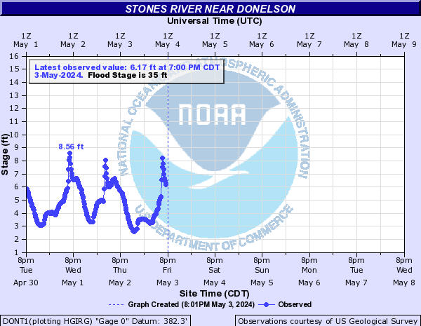
The Flood Watch remains for us until tomorrow morning. The only river/creek currently of concern in Davidson & Williamson County is Stones River at Donelson (the subject of the Flood Advisory for Davidson County). With these rainfall rates (low compared to last weekend) and the fact the rain is on its way out, there is reason to be encouraged. Note that flooding can still occur due to rainfall out of our county, so we are watching things closely.
The Cumberland River at Nashville is forecast to barely reach Action Stage tomorrow, which would still be 5′ below Flood Stage:

We don’t expect any problems with the Harpeth River in Franklin (and also at Bellevue – not pictured):

Check with @NashSevereWx on Twitter for more frequent updates.
Categories: Forecast Blogs (Legacy)