Nashville Severe Weather

Severe & Winter Weather Info and Forecasts for Davidson & Williamson Counties in Middle Tennessee

Friday, March 27th, 2026

Menu

  • Home
  • Who We Are
    • About Us
    • Mike & Albree
  • Resources
    • Radar
    • NWS Nashville
    • What To Do: Tornado Watch vs. Warning
    • River/Creek Flood Stages
    • Taking Care of Storm Anxiety
  • Shop Merch
    • Store
    • Shopping Cart
  • Donate
    • Patreon
    • Paypal
  • Follow us on Twitter
  • Follow us on Threads
  • Follow us on Bluesky
  • Follow us on Instagram
  • Subscribe to our YouTube Channel

A Few Chances for Rain and Severe

By Will on Monday, March 9, 2026 @ 9:51 am • ( Leave a comment )

Low-End Severe Risk Today, Stay Connected

By Andrew on Saturday, March 7, 2026 @ 9:00 am • ( Leave a comment )

Cold but Slowly Warming

By Will on Tuesday, December 30, 2025 @ 10:41 am • ( Leave a comment )

Cold and Clear

By Will on Monday, December 29, 2025 @ 1:14 pm • ( Leave a comment )

Eyes on Next Weekend

By Andrew on Sunday, October 12, 2025 @ 4:06 pm • ( Leave a comment )

Cool, Foggy Mornings; Warm Afternoons, Rain-free

By Andrew on Saturday, October 11, 2025 @ 12:05 pm • ( Leave a comment )

Rain Chances Down, Heat Turns Up

By Elan on Thursday, June 19, 2025 @ 7:02 pm • ( Leave a comment )

Side note: we could see some areas of locally dense fog early Friday morning. Take it slow in the morning if you encounter any.

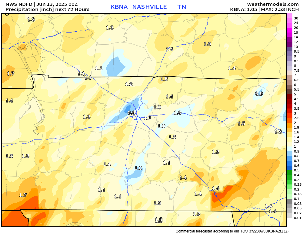
We are currently sitting at the 4th wettest start to the year ever, with BNA recording 35.01″ of rain so far. Your backyard may have seen slightly more/less. read more

Low Threat for Severe Weather, Flash Flooding Tonight

By Elan on Wednesday, June 18, 2025 @ 6:47 pm • ( Leave a comment )

Just prior to publishing, Davidson Co. have been included in a Severe Thunderstorm Watch until midnight. This does not mean Williamson Co. is in the clear – stay connected! All info in the blog holds true. read more

Very Low Chance of Severe Weather Wednesday Evening/Night

By Elan on Tuesday, June 17, 2025 @ 7:35 pm • ( Leave a comment )

I know you’ve heard this one before, but showers/storms continue to move thru our area this evening. Activity should diminish as we get closer to sunset. We’ve seen a ton of rain recently, so creeks will easily fill up with any heavy rainfall. Avoided flooded roadways. read more

Light (And Heat) At The End of the Tunnel

By Elan on Monday, June 16, 2025 @ 6:20 pm • ( Leave a comment )

Storms will continue thru this evening. Follow along with us on all of our socials, and you can always check the radar anytime on our website here: Radar | Nashville Severe Weather

Storms are expected to remain below severe limits, but heavy rain and frequent lightning may be an issue. Activity should decrease as we get closer to sunset. read more

C + P Forecast thru Thursday

By Elan on Sunday, June 15, 2025 @ 6:44 pm • ( Leave a comment )

Wattery winners on this Father’s Day have mostly been confined to those in Williamson County. Still a few more showers hanging around in the vicinity, but activity will continue to decrease as we head towards sunset. read more

Rain/Storm Chances Continue Daily

By Elan on Saturday, June 14, 2025 @ 12:48 pm • ( Leave a comment )

I know I sound like a broken record, but I’m not sure how else to phrase it.

Each day thru at least Thursday will consist of Wattery chances, mostly confined to the afternoon/evening hours.

Impossible to know if plan ‘x’ will be dry at ‘y’ time – just part of the Wattery. read more

Wattery Chances Daily For At Least a Week

By Elan on Friday, June 13, 2025 @ 3:36 pm • ( Leave a comment )

We’ve seen quite a bit of rain already today, with more moving thru as of the time of writing (3:30p). Activity should decrease as we head closer to sunset. You can check the radar anytime on our website here: Radar | Nashville Severe Weather – and we’ll be sending out updates on all our socials as needed. read more

Unsettled Pattern Making Itself At Home

By Elan on Thursday, June 12, 2025 @ 7:34 pm • ( Leave a comment )

Wattery winnings stayed away from us today, but not sure that will hold for very long.

Daily rain/storm chances will be in the forecast from Friday until at least Wednesday.

Scattered showers and thunderstorms will be possible each day, most likely in the afternoon and evening timeframe. read more

Daily Rain/Storm Chances Return Thursday, Continue Into The Weekend

By Elan on Wednesday, June 11, 2025 @ 5:40 pm • ( Leave a comment )

Unfortunately, models have upped our rain chances for Thursday.

HRRR model (and others) think we could see some scattered showers/thunderstorms during the afternoon/evening timeframe. Impossible to know exactly when and where, that’s just part of the Wattery. read more

Few Dry Days While We Heat Up

By Elan on Tuesday, June 10, 2025 @ 4:03 pm • ( Leave a comment )

We’ll get a well-earned break from the rain thru Thursday.

While we get a few dry days strung together, temperatures will be warming up. Rest of the forecast temps will be in the upper 80s/low 90s. read more

Posts navigation

‹ Newer 1 … 21 22 23 24 25 26 27 28 29 30 31 … 558 Older ›

Subscribe to Blog via Email

Enter your email address to subscribe and receive daily forecast updates directly to your inbox.

Privacy & Cookies: This site uses cookies. By continuing to use this website, you agree to their use.
To find out more, including how to control cookies, see here: Privacy Policy
  • Top categories: Forecast Blogs (Legacy) / Featured Blog / Tweet
Proudly powered by WordPress | Theme: Broadsheet by Pro Theme Design.