
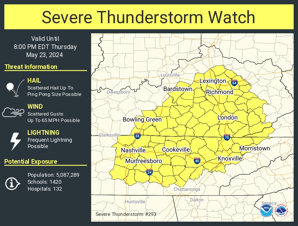
Both of our counties (Williamson and Davidson) are under a Severe Thunderstorm Watch until 7pm, for the possibility of damaging straight-line winds and hail. Another concern today will be flash flooding. If you come across a flooded roadway, turn around – don’t drown. We are not concerned about tornadoes today.
Storms have begun to pop-up and will continue to do so over the next several hours. Trying to nail down the timing is difficult due to the scattered, sporadic nature of the cells.

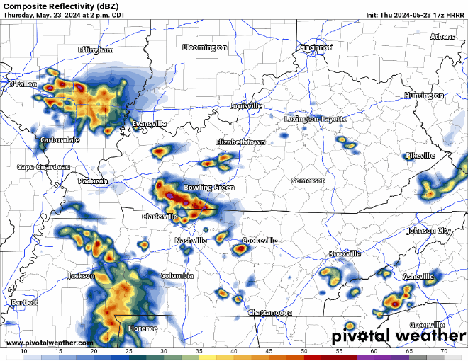
The HRRR model gives its’ best guess of what the radar could look like thru 10pm tonight. Models generally have a tough time handling situations like these, this is just to give a general idea of what is expected. Regardless of if storms reach severe criteria or not, they’ll likely contain a good bit of cloud to ground lightning. When thunder roars, go indoors.
I wish I had a confident answer on if we would be clear by graduation/other outdoor plans time tonight, but it’s just tough to know right now. I see a few signs that make me feel good about getting away with a dry diploma, and a few discouraging signs. Best thing to do is watch radar trends and keep fingers crossed. We’ll be tweeting updates as needed and will go live on YouTube if a warning is issued for either part of our two counties.
This upcoming Memorial Day weekend will be a great one to be weather aware, as we’ll have severe weather chances to deal with daily.

The Storm Predicition Center has both our counties outlooked with a 5% chance of both damaging straight-line winds and hail within 25 miles for Friday.
We should get away with a dry Friday morning, storm chances don’t begin to ramp up until the afternoon hours.

This run of the HRRR model holds off most of the activity until after 3pm and leaves us with a wet and stormy evening. Similar to today, regardless of if the storms are strong to severe, cloud to ground lightning will be possible in any of the storms. Having an indoor backup plan will be a good idea.
Anddd yet again on Saturday we’ll be dealing with some low chances for severe weather, a 5% chance of severe weather within 25 miles.

Another similar set up to today and Friday, scattered strong to severe storms will be possible, most likely in the afternoon and evening hours. Still a lot of details to be worked out.
Sunday has the potential to be a busy day.

Both counties are currently outlooked with a 30% chance of severe weather within 25 miles. This forecast can and will likely change several times over the next couple of days! No need to hit a panic button, but something to keep in mind if you are planning on attending any outdoor events.
The main thing to keep in mind over the next several days will be to stay weather aware and check back for updates. All this information can change. We’ll keep you updated as new data comes in.

Categories: Featured Blog