

Ice remains. It was 5° at BNA overnight. Many local areas colder than that.
Temps above freezing – barely, briefly – this afternoon. Sunlight and light winds will erode but not eliminate ice sheets. Back down to 20° overnight and Monday morning.
Ice should linger through the Monday AM commute.
Freezing temps should end between 9-10 AM Monday, rising to 46° Monday afternoon. Commence the snowmelt! Shady areas may hold ice longer, perhaps through the PM commute. Remember fam, ice will melt at varying rates.
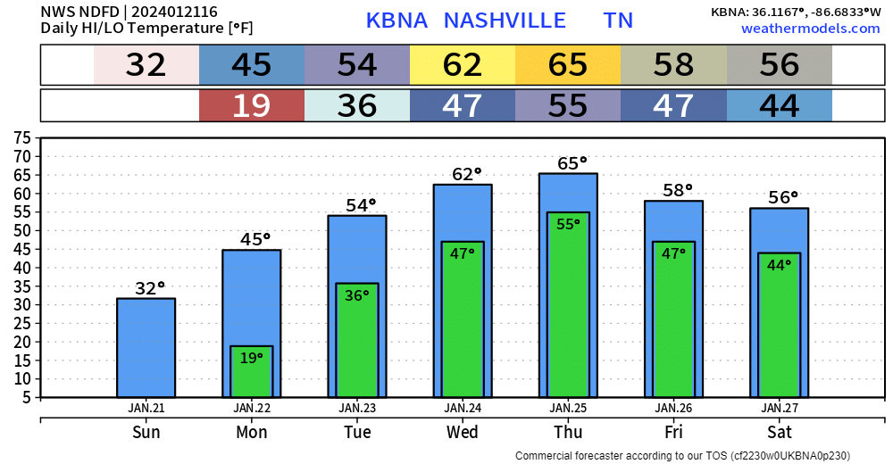
Lows Tuesday morning are tricky. BNA’s low is 37°. Other local areas may be colder than that, but I don’t think it’ll do much to refreeze washed away ice and snow.
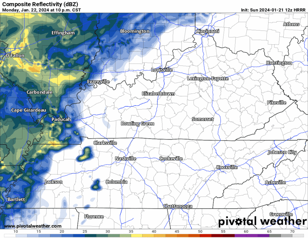
Rain approaching Tuesday morning should wash away any surviving, hardpacked ice.
47° late morning Tuesday, afternoon high 54°, with rainfall melting and shoving ice away. Beginning Tuesday, we will not get below freezing for at least the next week.
Expect temps and rain to clear ice Tuesday.
Rain heaviest Tuesday through Thursday. Forecast rain totals increased from 2″ to 3″ to 3″ to 5″.
This may rise rivers and streams.
[S]nowmelt plus cold and soggy grounds with several inches of rain falling on top of that is a recipe for flooding and rises on our area rivers and lakes. A Flood Watch may be necessary for parts or all of the [area] in a couple days if these model trends continue.
NWS-Nashville, AM Forecast Disco, 1/21/24
A Flood Watch is possible mid/late this week.
Severe weather potential Thursday remains a topic, but news is good.
[G]uidance has been suggesting that 60+ dewpoints may make it northward into parts of our [area] in the Wednesday or Thursday timeframe, and given the ample shear depicted a low end severe threat could result – although this is highly uncertain at this range.
NWS-Nashville, AM Forecast Disco, 1/21/24
SPC says “predictability too low” to outlook us for severe potential.
Models disagree as usual. Yesterday, the Euro model advertised severe-storm-capable instability with 60° dewpoints. Today it has dewpoints in the upper 50°s with only a narrow band of much weaker instability. The GFS model has none of this.
Thunderstorms maybe, but the data shows no basis for severe storm alarm.
Concern about a severe storm event Thursday is decreasing.
Day 6-10, Day 8-14, and Weeks 3-4 outlooks suggest above-average temps. This does not rule out another winter event, but it suggests that if we get one, arctic air is unlikely to race in behind it and lock in ice and snow for a week.
A repeat of this weeklong snow is unlikely in the foreseeable future.
Quick References:
Weather changes constantly.
Follow @NashSevereWx on Twitter for any changes to this forecast.
Live coverage during tornado and severe thunderstorm warnings:

Look good.
Support the mission.

We are 100% community supported. No ads. No subscription fees. Keep it free for everyone.


Categories: Forecast Blogs (Legacy)
You must be logged in to post a comment.