
As of 4pm, surface temperatures throughout our two counties are ranging from 37-40°, which is the reason the precip moving thru will mostly be light rain, although temperatures way up are very cold which could call for some flurries mixing in.

The HRRR model (above) illustrates the scattered light rain/snow mix possible throughout the evening, any flurries falling will melt on contact with the ground.
Travel should not be impacted, as road/surface temperatures are expected to stay above freezing throughout today and tonight.

NWS Nashville issued a Winter Weather Advisory which was confined to the Plateau and does not include us. If you really want to see some snow, the Plateau will be your best chance. I suppose a few places could see some snow briefly stick on elevated surfaces, especially in higher elevations, but with our temperatures expected to stay in the mid 30s, it just seems very unlikely.
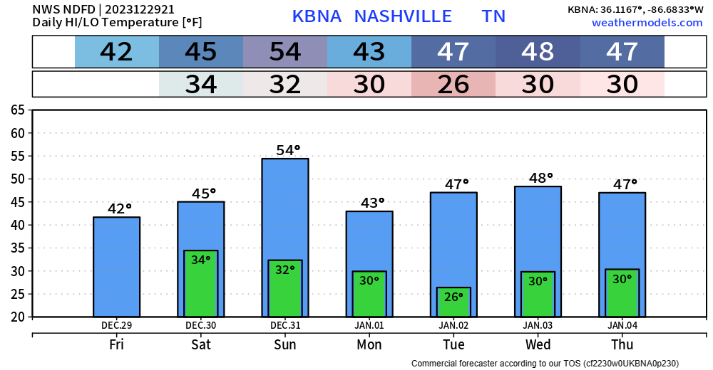
Saturday and Sunday will be cold and dry as we wrap up 2023. Music City Bowl should be dry with temps in the 40s.
New Year’s Day looks to follow suit, with precip chances increasing towards the middle of next week.
“This low looks intense enough to perhaps warrant another rain and snow mix for our area.”
– NWS Nashville Afternoon Forecast Discussion
Still a ways away, and the forecast will likely change between now and then, but something to keep an eye on.
Quick References:
Weather changes constantly.
Follow @NashSevereWx on Twitter for any changes to this forecast.
Live coverage during tornado and severe thunderstorm warnings:

Look good.
Support the mission.

We are 100% community supported. No ads. No subscription fees. Keep it free for everyone.


Categories: Forecast Blogs (Legacy)
You must be logged in to post a comment.