
Both of our counties are under a Winter Weather Advisory until noon today. Isolated snowfall amounts of one inch are possible in some isolated areas, but most places will be around half an inch.
We shouldn’t see any major travel impacts, but any snow that falls will stick, so take it easy on the roads and give yourself some extra time today. Snow should end around noon, and we may see temps briefly get above freezing, which will help with melting.
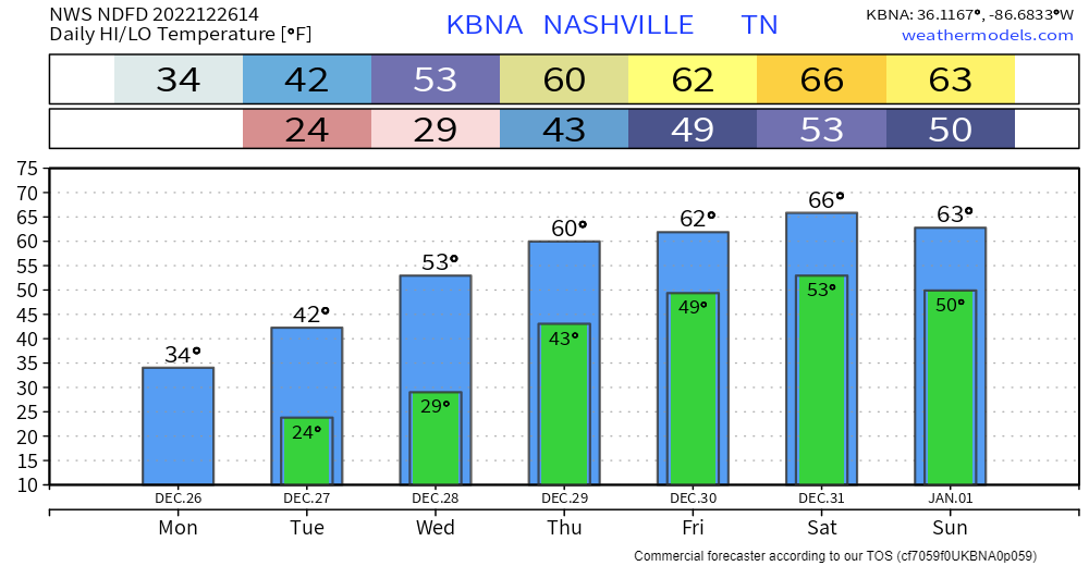
Temperatures will fall into the low 20’s again tonight, which will refreeze any moisture on the roads. Maybe some more flurries tonight, but no additional accumulation expected.
Be careful with pipes over the next couple of days. We’ll finally get above freezing which could expose pipes that have broken.
Tuesday we’ll dry out and really begin to start the warmup. Tuesday night and Wednesday night we’ll dip below freezing for at least the last time in 2022. A nice and deserved break.
We’ll make it to the 60’s by Thursday and will keep those high temps through the new year. Rain chances creep back in on Friday. Hopes are that the rain moves east by NYE, but confidence in that is low right now. We’ll get more of an idea on timing as we get closer.
Quick References:
Weather changes constantly.
Follow @NashSevereWx on Twitter for any changes to this forecast.
Live coverage during tornado and severe thunderstorm warnings.

Look good.
Support the mission.

We are 100% community supported. No ads. No subscription fees. Keep it free for everyone.


Categories: Forecast Blogs (Legacy)
You must be logged in to post a comment.