
This morning my friend Melissa asked “when do I need to pay attention to this?”
Tonight, Melissa. Tonight.
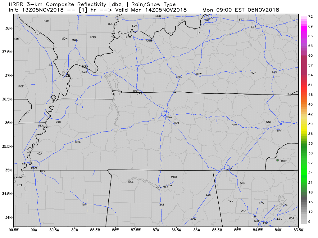
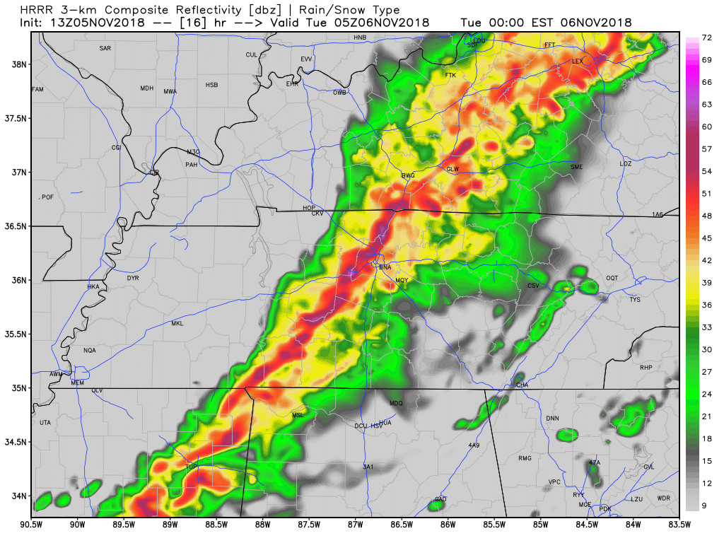
A line of strong to severe thunderstorms will form and move from northwest to southeast across Middle Tennessee tonight. All models show this. Below is one, the HRRR, one of my favorite weather models:
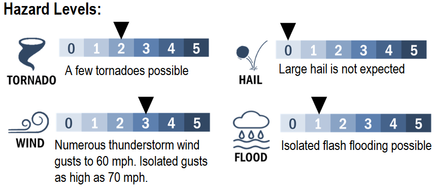
Hazard levels for all of Middle Tennessee, from NWS-Nashville:
ETA
Officially, the ETA is 9 PM to midnight to Nashville and most of Will Co, and 10 PM to 2 AM for SE Will Co (College Grove and surrounding communities).
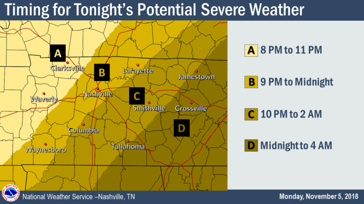
The HRRR model thinks it’ll be 11 PM to midnight for most of Nashville and Will Co., then after midnight for SE Will Co.:
Damaging Winds
Storm Prediction Center outlooks continue to move back and forth.
The current outlook puts Nashville and Will Co inside a 30% probability of a damaging wind event happening within 25 miles of you tonight.
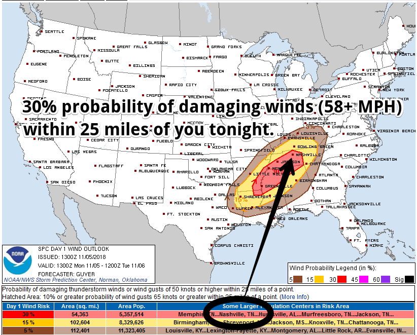
I’ve read too many accounts of damaging wind fatalities from the wind blowing a tree on a vehicle, killing the occupants.
Don’t ride this out in a vehicle under a tree, y’all.
Tornadoes
The current outlook puts Nashville and Will Co inside a 10% probability of a tornado happening within 25 miles of you tonight.
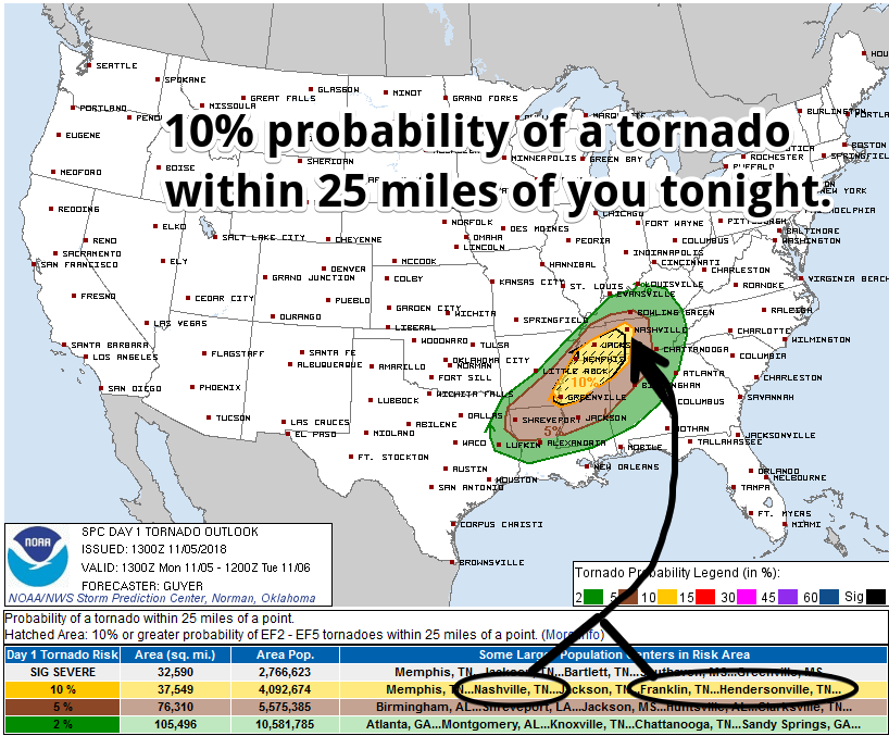
Update:
Storm Prediction Center update now includes Will Co/Franklin in the "significant severe" tornado section, meaning there's a 10% probability of an EF2-EF5 occurring within 25 miles of us tonight. pic.twitter.com/xGVGFHlvrn
— NashSevereWx (@NashSevereWx) November 5, 2018
Hail
Not expecting hail today. But if you hear hail, watch out, because it’ll indicate an organized storm with some bad wind close by.
Why The Storms May Not Be So Bad
In a phrase: “insufficient CAPE.”
For damaging winds to descend and tornadoes to form, there has to be at least some CAPE — Convective Available Potential Energy.
What’s CAPE?
If making a storm is like making an omelette, CAPE is the egg. You can have a chef, some ham, appropriate cheese, a skillet, a functioning stove, a mixing bowl with a Brand New Spatula, and the motivation to whip up that omelette, but if you don’t have egg — or you have very little egg — you’re not making much of an omelette.
Tonight we will have all the other ingredients for a well-constructed omelette, we just aren’t sure if there will be enough egg to make one.
The HRRR model shows no CAPE at 6 PM tonight, then, over the next six hours, it thinks CAPE will get pulled in from the south to fuel these storms and make that omelette.
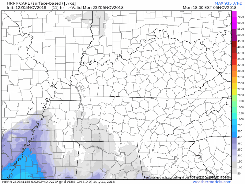
I’ve heard that before.
One way to prevent CAPE from arriving is for rain to form early tonight and consume the CAPE the storm line will need for big storms later tonight. Therefore, we are in favor of rain coming before the storms. Not sure we’ll get that early evening rain, but I’m pulling pretty hard for it.
There also may not be enough time for sufficient CAPE to arrive by the time the big storm line gets here. To return to the omelette analogy, you need enough egg whites and/or yolk to make the omelette, without it the omelette won’t come together. A little CAPE just isn’t going to do the job. Wind energy and shear aloft will be so powerful, we’re going to need more than a little CAPE to build the storms. If it’s just a little CAPE, the cloud updrafts will get sheared apart by powerful winds blowing overhead.
The CAPE question is one reason why the probabilities can also be fairly read as a 90% chance no tornado will occur within 25 miles of you tonight, and a 70% chance no damaging wind event will occur within 25 miles of you tonight.
If you only think in song — I apologize in advance — for this misheard lyric:

Four local weather balloons will be launched today. Two important launches are scheduled for 5-6 PM and 11 PM to midnight. Weather balloons will sample the CAPE to provide us critical information later tonight.
All that said, if this comes together, you need to be in a safe space. Resist any urge to go outside and try to “see” it because you won’t be able to see anything other than darkness and rain.
Heavy Rain
Strong/Severe storms or not, heavy rain is on the way.
Flash flooding is possible. The Weather Prediction Center says the odds of a flash flood event are between 10% and 20%.
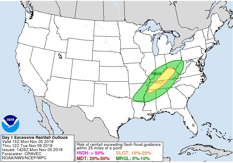
Rain and storms should depart shortly after midnight.
My Four Things Theory
In my view the Responsible Citizen Does Four Things During Severe Weather Season. Right now we’re in the third category. As for the fourth category — note no warnings are ever posted to this website, although we do post them to Twitter.
(1) Several Days Before — Awareness and Preparation: this occurs at least few days before any severe weather event. Know your safe places, have a way to get weather watches and warnings, and if you’ve not done all that stuff a few days is plenty of time to figure it out all out. Your daily routine should include a way to get severe weather forecasts, either from your crap app, or much better, by watching your fave local TV meteorologist, reading this website, or for those inclined, reading NWS-Nashville and Storm Prediction Center technical discussions.
(2) Few Days/Day Before — Risk Assessment and Planning: A few days to a day before the potential severe weather event, assess the risk responsibly by understanding the forecast is a set of probabilities for your region. The existence of a tornado, hailer, flood, or lightning strike (for example) 36 hours away at BNA, your garage sale, photo shoot, or ball game is not and cannot be specifically known exactly. At this range the forecast is a probability, the “e” in ETA means “estimated.” It’s important to understand the forecast expressed as a probability and range is not a guess; instead, it’s the best actionable information we have, forecasters aren’t gamblers willing to bet your safety on an exact result in a race to be “right,” whatever that means. So we give you probabilities and timing information in the most intellectually honest ways possible — this includes probabilities, caveats, and estimated arrival times because that’s the state of the science today. Those of you who think “must be great to have a job when you can be wrong half the time” either struggle with this or are getting the weather off a crap app.
Anyway, if you have something going on when the weather is forecast to hit, take all provided information and assess the risk for yourself and decide whether to cancel, delay, postpone, reschedule, or proceed based on your risk tolerance, your need to do it, and your ability to shelter in time should the event occur.
Avoid recency bias, which says “this forecast recently happened/didn’t happen; therefore, the same thing will/won’t happen again this time.” This is fallacy. Confirmation bias — “I really want ‘x’ to happen so I’m going to discount/ignore information to the contrary” — should also be avoided. Dismiss Old Wives Tales about tornadoes not crossing rivers, hills protecting you from tornadoes, it never snows here, etc. The science may not be perfect, but it’s better than what grandma thought.
(3) Day Of — Closely Monitoring: The bad stuff is getting close so you should actively monitor multiple reliable data sources for a warning and any forecast updates/changes. You are not going to get caught unaware. Higher resolution models are in range, spitting out data hourly. Radars show storm development. Satellite scans overhead. Probabilities become more specific. ETAs improve. NWS-Nashville issues more specific weather outlooks. The Storm Prediction Center issues severe storm/winter mesoscale discussions and Watches. Information can come quickly. You have time to adjust your plans accordingly.
(4) Warning Issued — Immediate Action: A Warning is issued. Unfortunately, the low probability of a warning happening to you happened. Time to take action. You planned. You were ready for it. The bad stuff in the storm won’t hit everyone in the warning area, but everyone in the area is too close to occurring and imminent severe weather to ignore. Time to shelter.
Got kids? Make them wear helmets in case of warnings. One horrible lesson from April 27, 2011, is that many injuries to children could have been prevented or reduced had kids been wearing a helmet. I’m a grown man and I wear one during warnings.
Also, remember your shoes! I have stood in major and minor storm damage, you need shoes.
Severe weather refresher — terminology, tips, safety — here.
Also if you’re one of those people who gets irate when the Titans game is interrupted to deliver potentially life-saving weather information to someone, plan ahead and figure out another channel (ESPN, streaming may be options) to watch the Titans game in case Channel 2 has to break in. I understand that the world revolves around your love of the Titans and nothing should get in your way, your majesty. I know you don’t care about someone else getting a warning if it means you miss another punt by the Cowboys, but be sure you have a way to get warnings. Jerry’s World may be tornado-proof. Not sure your house is.
Much more about this later today and tomorrow on Twitter and on this dot com.
If we get a warning, Andrew will be on Periscope. Will will be looking for your #tSpotter reports of damage or other weather shenanigans. I’ll be tweeting like crazy on Twitter.
Rest of the Week
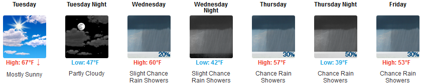
Rain is likely late Thursday.
Freezing temps likely early Saturday and Sunday mornings.

Categories: Forecast Blogs (Legacy)
You must be logged in to post a comment.