
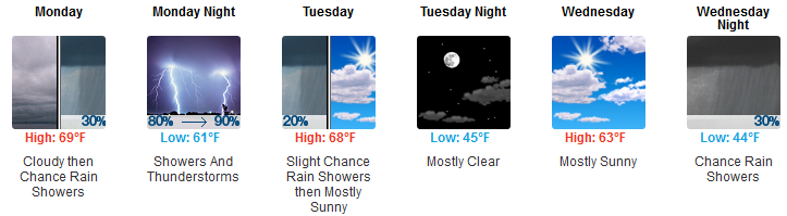
Today
It’s going to get breezy this afternoon, even windy, with gusts up to 25 MPH.
High today 64°.
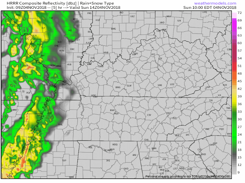
Afternoon rain is expected. It should cross the Tennessee River around lunchtime and arrive here around late afternoon, aka, around the time it’s getting dark. The HRRR model illustrates:
Severe Weather Potential Monday Night
What
- Damaging Winds are the main concern.
- Tornadoes are possible, but less likely than the damaging wind threat.
- Hail isn’t being ruled out, but is unlikely.
Because showing your work is important, let me toss some science at you.
Speaking generally about a very large outlooked-for-severe-weather area, this morning the Storm Prediction Center wrote that:
Impressive wind profiles with large 0-1 km hodographs and intense mid-upper jet should foster organized storms including embedded bowing segments and supercells with low-level mesocyclones capable of mainly damaging wind and tornadoes, though some hail will also be possible. A moderate risk upgrade might be warranted for a portion of this region in later outlooks.
NWS-Nashville, writing about Middle Tennessee and not the entire area:
Models are in pretty good agreement that mid 60 dew points will be pulled as far north as our northern border just ahead of the cold front the surface low will be dragging. The tongue of rich, Gulf moisture will support enough destabilization to achieve between 250-500 J/kg of mixed layer CAPE despite the nocturnal timing.
A 50-65 kt low level jet will ramp up ahead of the cold front leading to 40 kts of 0-1 km shear and 45-50 kts of 0-3 km shear. The severe threat will be in the form of a QLCS capable of damaging straight line winds and a few tornadoes. I don`t expect much in the way of hail given poor lapse rates.
Thus we have what we need to make big storms generally speaking, and in our region.
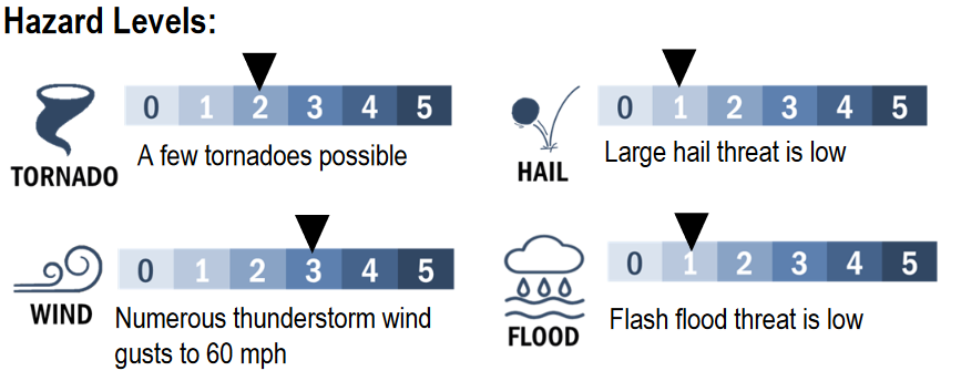
Here are our hazard levels:
Important Caveat!
Before I get to probabilities, do not miss this caveat:
Despite the overlap of impressive shear and modest instability, this is not a slam dunk event. Models are hinting at a shield of showers ahead of the main line of storms. This could slowly gobble up the limited CAPE and limit the severity of storms along the front in our area.
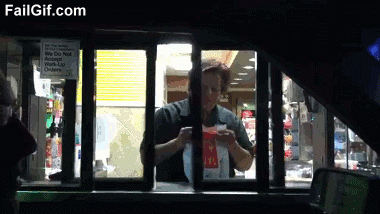
If light rain comes before the “main event” tomorrow night and uses up all our CAPE, that would be excellent. It would be like the Severe Storm Hamburglar burgling your storm burger, kinda like this:
The Avocado Outlook of Storm Probabilities
Probabilities remain the same as they were yesterday, but with one important change.
The probability of a severe weather event (wind and/or tornado and/or hail) happening within 25 miles of you is 30%.
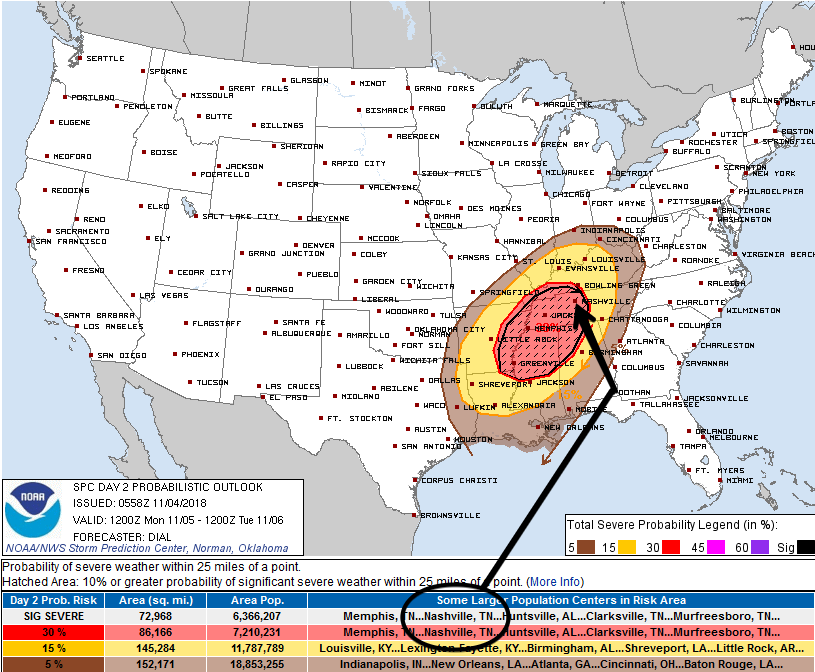
The change is that we are now in the shaded (“hatched”) area, which means the probability of a “significant severe” event (within the 30% area) is 10% or greater. “Significant severe” events include:
- A tornado that produces EF2 or greater damage.
- Wind speeds of 75 mph (65 knots) or greater.
Hail 2 inch in diameter or larger. (I think we can dismiss the large hail threat, at least we can right now).
These probabilities will be updated several times. We will bring you those updates either here or on Twitter, which you can find here or, by scrolling down, here.
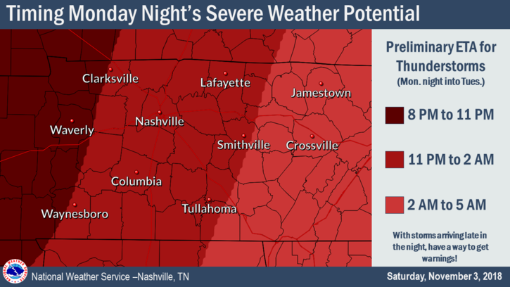
Timing
Same as yesterday for the severe stuff. ETA is Monday night at midnight, plus or minus a few hours. From NWS-Nashville’s discussion:
The I-65 corridor`s window appears to be at the earliest around 11 PM to 2 AM.
And here’s their graphic:
Let’s hope for rain before that, burgling all our instability and causing the severe setup here to fall apart.
Should You Panic?
Nope. Be prepared, stay informed, it’s likely nothing will happen to you. You will probably be fine. But you should be ready and respect these storm systems.
Severe weather is a low probability, high impact event. The probability any of this will happen to you is low, but if it does the impact could be minor, moderate, or even life-threatening. Reasonable safety steps dramatically reduce your risk of injury.
My Four Things Theory
In my view the Responsible Citizen Does Four Things During Severe Weather Season. Right now we’re in the second category.
(1) Several Days Before — Awareness and Preparation: this occurs at least few days before any severe weather event. Know your safe places, have a way to get weather watches and warnings, and if you’ve not done all that stuff a few days is plenty of time to figure it out all out. Your daily routine should include a way to get severe weather forecasts, either from your crap app, or much better, by watching your fave local TV meteorologist, reading this website, or for those inclined, reading NWS-Nashville and Storm Prediction Center technical discussions.
(2) Few Days/Day Before — Risk Assessment and Planning: A few days to a day before the potential severe weather event, assess the risk responsibly by understanding the forecast is a set of probabilities for your region. The existence of a tornado, hailer, flood, or lightning strike (for example) 36 hours away at BNA, your garage sale, photo shoot, or ball game is not and cannot be specifically known exactly. At this range the forecast is a probability, the “e” in ETA means “estimated.” It’s important to understand the forecast expressed as a probability and range is not a guess; instead, it’s the best actionable information we have, forecasters aren’t gamblers willing to bet your safety on an exact result in a race to be “right,” whatever that means. So we give you probabilities and timing information in the most intellectually honest ways possible — this includes probabilities, caveats, and estimated arrival times because that’s the state of the science today. Those of you who think “must be great to have a job when you can be wrong half the time” either struggle with this or are getting the weather off a crap app.
Anyway, if you have something going on when the weather is forecast to hit, take all provided information and assess the risk for yourself and decide whether to cancel, delay, postpone, reschedule, or proceed based on your risk tolerance, your need to do it, and your ability to shelter in time should the event occur.
Avoid recency bias, which says “this forecast recently happened/didn’t happen; therefore, the same thing will/won’t happen again this time.” This is fallacy. Confirmation bias — “I really want ‘x’ to happen so I’m going to discount/ignore information to the contrary” — should also be avoided. Dismiss Old Wives Tales about tornadoes not crossing rivers, hills protecting you from tornadoes, it never snows here, etc. The science may not be perfect, but it’s better than what grandma thought.
(3) Day Of — Closely Monitoring: The bad stuff is getting close so you should actively monitor multiple reliable data sources for a warning and any forecast updates/changes. You are not going to get caught unaware. Higher resolution models are in range, spitting out data hourly. Radars show storm development. Satellite scans overhead. Probabilities become more specific. ETAs improve. NWS-Nashville issues more specific weather outlooks. The Storm Prediction Center issues severe storm/winter mesoscale discussions and Watches. Information can come quickly. You have time to adjust your plans accordingly.
(4) Warning Issued — Immediate Action: A Warning is issued. Unfortunately, the low probability of a warning happening to you happened. Time to take action. You planned. You were ready for it. The bad stuff in the storm won’t hit everyone in the warning area, but everyone in the area is too close to occurring and imminent severe weather to ignore. Time to shelter.
Got kids? Make them wear helmets in case of warnings. One horrible lesson from April 27, 2011, is that many injuries to children could have been prevented or reduced had kids been wearing a helmet. I’m a grown man and I wear one during warnings.
Also, remember your shoes! I have stood in major and minor storm damage, you need shoes.
Severe weather refresher — terminology, tips, safety — here.
Also if you’re one of those people who gets irate when the Titans game is interrupted to deliver potentially life-saving weather information to someone, plan ahead and figure out another channel (ESPN, streaming may be options) to watch the Titans game in case Channel 2 has to break in. I understand that the world revolves around your love of the Titans and nothing should get in your way, your majesty. I know you don’t care about someone else getting a warning if it means you miss another punt by the Cowboys, but be sure you have a way to get warnings. Jerry’s World may be tornado-proof. Not sure your house is.
Much more about this later today and tomorrow on Twitter and on this dot com.
Rest of the Week
Rain is likely Thursday.
Finally, from NWS-Nashville:
Next weekend we will likely be dealing with a freeze in most locations, if not a hard freeze.
Highs only in the 50°s.

Categories: Featured Blog
You must be logged in to post a comment.