
(If you read our forecast this morning, the new information on tomorrow night’s severe storm threat is in blue).
Cold Rain
Official NashSevereWx Correspondents dispatched to Memphis this morning confirm the rain falling now is cold.
This rain should hang around until early/mid evening. No lightning or storm concerns tonight.
Severe Weather Potential Monday Night
What
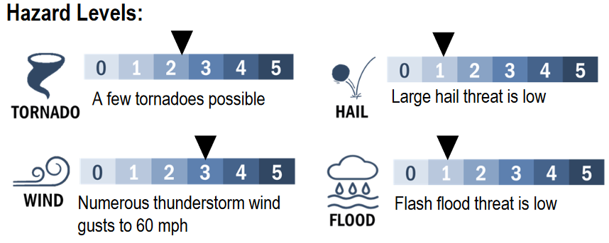
- Damaging Winds are the main concern.
- Tornadoes are possible, but less likely than the damaging wind threat.
- Hail isn’t being ruled out, but is unlikely.
This afternoon, the Storm Prediction Center wrote that:
Both damaging winds and tornadoes will be possible, with tornado potential more heavily weighted toward areas with warmer, more unstable air from northern MS across middle TN and perhaps southern KY and northwest AL. A strong tornado cannot be ruled out, with effective SRH potentially to 500 m2/s2.
Thus we have what we need to make big storms generally speaking, and in our region.
Here are our hazard levels:
Important Caveats — Pre Frontal Convection and Shear to Instability Ratios
This is important:
Despite the overlap of impressive shear and modest instability, this is not a slam dunk event. Pre-frontal convection could interfere with available instability. Also, the shear to instability ratio may be too great. But, if deep updrafts flourish, they will easily rotate, and low level Storm Relative Helicity will be supportive of tornadogenesis.
Let’s unpack all this.
The bad stuff is supposed to hit around midnight, plus or minus a few hours (more on this below).
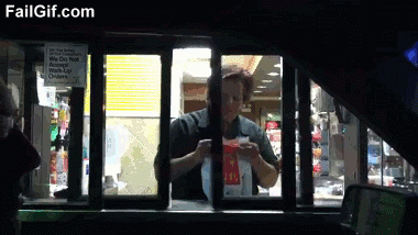
We hope it rains early Monday night before the bad stuff is supposed to hit. This early evening rain is what is meant by “pre-frontal convection.” We want it because it would use up all our CAPE, and limit or altogether eliminate severe storm chances.
Early evening rain would be like a Severe Storm Hamburglar burgling your storm burger, kinda like this:
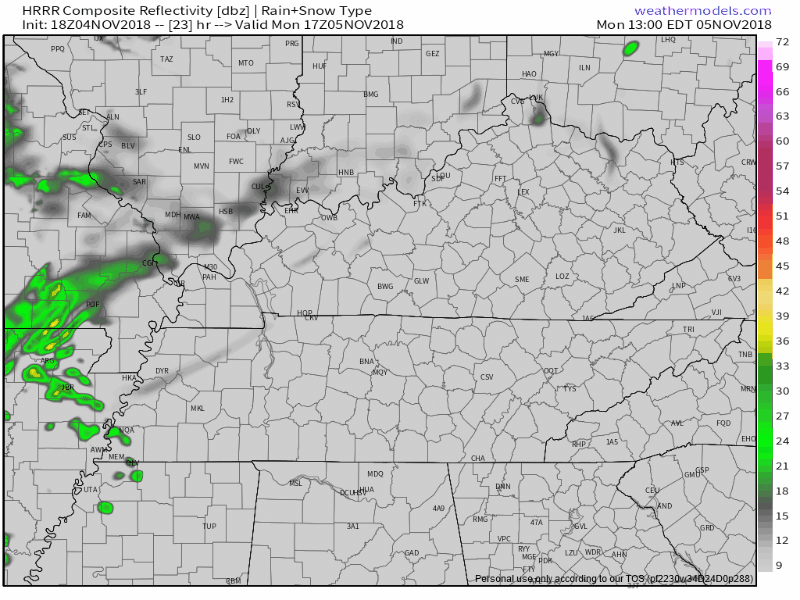
The HRRR model is already advertising this “pre-frontal convection” (see below) in the form of light rain arriving around 6 PM. A great sign!
Not all models agree.
The Euro model doesn’t have much rain early tomorrow night, which is a bad sign because it would make severe storms arriving closer to midnight more likely.
The NAM3 model predicts a messy radar, with rain arriving around 7 PM to 8 PM, which is kinda what we want (see below):
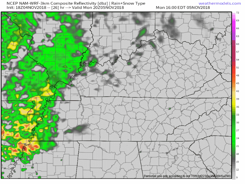
it is encouraging to see pre-frontal convection on some of these models, and the corresponding reduction of CAPE.
Also mentioned by NWS-Nashville as a potential reason severe weather may not happen here is an unfavorable shear to instability ratio. Even if we have a little CAPE, there may be so much wind shear aloft that any weak updraft gets blown apart by those intense winds aloft, kinda like the way you might destroy the top of a tower of bubblebath bubbles by blowing on it.
For all these reasons the probabilities are where they are.
The Avocado Outlook of Storm Probabilities
The probability of a severe weather event (wind and/or tornado and/or hail) happening within 25 miles of you remains 30%.
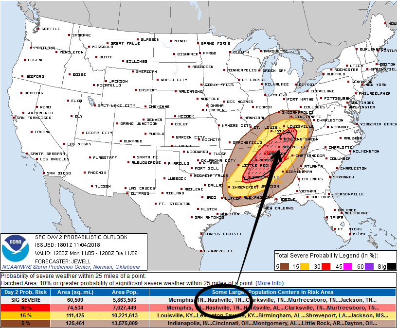
We’re also in the shaded (“hatched”) area, which means the probability of a “significant severe” event (within the 30% area) is 10% or greater. “Significant severe” events include:
- A tornado that produces EF2 or greater damage.
- Wind speeds of 75 mph (65 knots) or greater.
Hail 2 inch in diameter or larger. (I think we can dismiss the large hail threat, at least we can right now).
To look at it another way, there is a 70% chance a severe weather event will not occur within 25 miles of you tomorrow night. This threat is conditional. Remember this quote-o-caution from NWS-Nashville, above:
But, if deep updrafts flourish, they will easily rotate, and low level Storm Relative Helicity will be supportive of tornadogenesis.
These probabilities will be updated several times. We will bring you those updates either here or on Twitter, which you can find here or, by scrolling down, here.
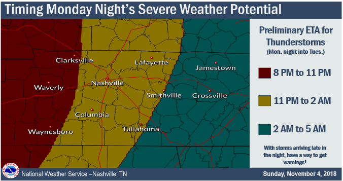
Timing
Same as yesterday for the severe stuff. ETA is Monday night at midnight, plus or minus a few hours. From NWS-Nashville’s discussion:
The I-65 corridor`s window appears to be at the earliest around 11 PM to 2 AM.
And here’s their graphic:
Let’s hope for rain before that, burgling all our instability and causing the severe setup here to fall apart.
Should You Panic?
Nope. Be prepared, stay informed, it’s likely nothing will happen to you. You will probably be fine. But you should be ready and respect these storm systems.
Severe weather is a low probability, high impact event. The probability any of this will happen to you is low, but if it does the impact could be minor, moderate, or even life-threatening. Reasonable safety steps dramatically reduce your risk of injury.
My Four Things Theory
In my view the Responsible Citizen Does Four Things During Severe Weather Season. Right now we’re in the second category.
(1) Several Days Before — Awareness and Preparation: this occurs at least few days before any severe weather event. Know your safe places, have a way to get weather watches and warnings, and if you’ve not done all that stuff a few days is plenty of time to figure it out all out. Your daily routine should include a way to get severe weather forecasts, either from your crap app, or much better, by watching your fave local TV meteorologist, reading this website, or for those inclined, reading NWS-Nashville and Storm Prediction Center technical discussions.
(2) Few Days/Day Before — Risk Assessment and Planning: A few days to a day before the potential severe weather event, assess the risk responsibly by understanding the forecast is a set of probabilities for your region. The existence of a tornado, hailer, flood, or lightning strike (for example) 36 hours away at BNA, your garage sale, photo shoot, or ball game is not and cannot be specifically known exactly. At this range the forecast is a probability, the “e” in ETA means “estimated.” It’s important to understand the forecast expressed as a probability and range is not a guess; instead, it’s the best actionable information we have, forecasters aren’t gamblers willing to bet your safety on an exact result in a race to be “right,” whatever that means. So we give you probabilities and timing information in the most intellectually honest ways possible — this includes probabilities, caveats, and estimated arrival times because that’s the state of the science today. Those of you who think “must be great to have a job when you can be wrong half the time” either struggle with this or are getting the weather off a crap app.
Anyway, if you have something going on when the weather is forecast to hit, take all provided information and assess the risk for yourself and decide whether to cancel, delay, postpone, reschedule, or proceed based on your risk tolerance, your need to do it, and your ability to shelter in time should the event occur.
Avoid recency bias, which says “this forecast recently happened/didn’t happen; therefore, the same thing will/won’t happen again this time.” This is fallacy. Confirmation bias — “I really want ‘x’ to happen so I’m going to discount/ignore information to the contrary” — should also be avoided. Dismiss Old Wives Tales about tornadoes not crossing rivers, hills protecting you from tornadoes, it never snows here, etc. The science may not be perfect, but it’s better than what grandma thought.
(3) Day Of — Closely Monitoring: The bad stuff is getting close so you should actively monitor multiple reliable data sources for a warning and any forecast updates/changes. You are not going to get caught unaware. Higher resolution models are in range, spitting out data hourly. Radars show storm development. Satellite scans overhead. Probabilities become more specific. ETAs improve. NWS-Nashville issues more specific weather outlooks. The Storm Prediction Center issues severe storm/winter mesoscale discussions and Watches. Information can come quickly. You have time to adjust your plans accordingly.
(4) Warning Issued — Immediate Action: A Warning is issued. Unfortunately, the low probability of a warning happening to you happened. Time to take action. You planned. You were ready for it. The bad stuff in the storm won’t hit everyone in the warning area, but everyone in the area is too close to occurring and imminent severe weather to ignore. Time to shelter.
Got kids? Make them wear helmets in case of warnings. One horrible lesson from April 27, 2011, is that many injuries to children could have been prevented or reduced had kids been wearing a helmet. I’m a grown man and I wear one during warnings.
Also, remember your shoes! I have stood in major and minor storm damage, you need shoes.
Severe weather refresher — terminology, tips, safety — here.
Also if you’re one of those people who gets irate when the Titans game is interrupted to deliver potentially life-saving weather information to someone, plan ahead and figure out another channel (ESPN, streaming may be options) to watch the Titans game in case Channel 2 has to break in. I understand that the world revolves around your love of the Titans and nothing should get in your way, your majesty. I know you don’t care about someone else getting a warning if it means you miss another punt by the Cowboys, but be sure you have a way to get warnings. Jerry’s World may be tornado-proof. Not sure your house is.
Much more about this later today and tomorrow on Twitter and on this dot com.
Rest of the Week
Rain is likely Thursday.
We may reach freezing early Saturday morning and early Sunday morning.
Weekend highs only in the 50°s.

Categories: Forecast Blogs (Legacy)
You must be logged in to post a comment.