
(If you read this morning’s blog, the text in blue is new)
Saturday was our last day of regular daylight because:
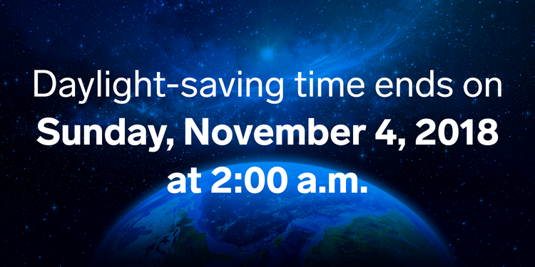
Your 25 Hour Sunday Looks Shabby
Sunup at 6:12 AM. Temp 48°. Afternoon high 65°.
Sundown at 4:48 PM. Four forty eight.
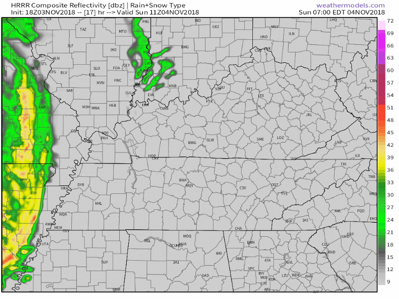
Rain should enter Memphis in the morning then work its way east.
ETA here mid-afternoon, aka “near dark.”
HRRR model below:
Monday Night Severe Weather
Monday afternoon it’s going to get unseasonably humid (dewpoints in the low 60°s) and breezy. After dark it’ll get windy (gusts to 34 MPH). You’ll think ruh-roh, it’s November, something is up. And you’d be right.
When
Monday night.
The NAM3 model has ETA 11 PM Monday into 2 AM Tuesday.
The Euro agrees with an ETA around midnight, give or take a few hours.
ETAs will require constant adjustment and updates. So will the forecast in general. Stay connected!
What
Quoting the Storm Prediction Center in Norman, OK:
Potential still exists for significant severe weather to transpire Monday evening and overnight, mainly from the lower MS Valley into the Tennessee Valley regions.
Note the language used: “potential.” Let’s not get carried away.
Mixed storm modes including a squall line and supercells are likely to develop along and ahead of advancing cold front Monday afternoon initially over the lower MS Valley, and continuing east into the TN Valley and Southeast States Monday night.
Two rounds of storms are possible. The first round — supercells — are less likely, but also usually more dangerous. The second round — a line of heavy rain and storms — is more likely, and can be dangerous, but aren’t as concerning (in my view, anyway) as supercells.
Impressive wind profiles with large hodographs and an intense upper jet will promote a threat for mainly damaging wind and tornadoes, though some hail will also be possible.
Meteorologists use a chart called a hodograph to visualize wind speed and direction. When a hodograph is large and curved the right way, it means there’s plenty of rotation and shear present, a necessary ingredient for severe storms, including tornadoes. As you just read, weather models for Monday night depict a large (and curved) hodograph. Therefore, damaging winds are the main concern, followed by tornadoes, then hail.
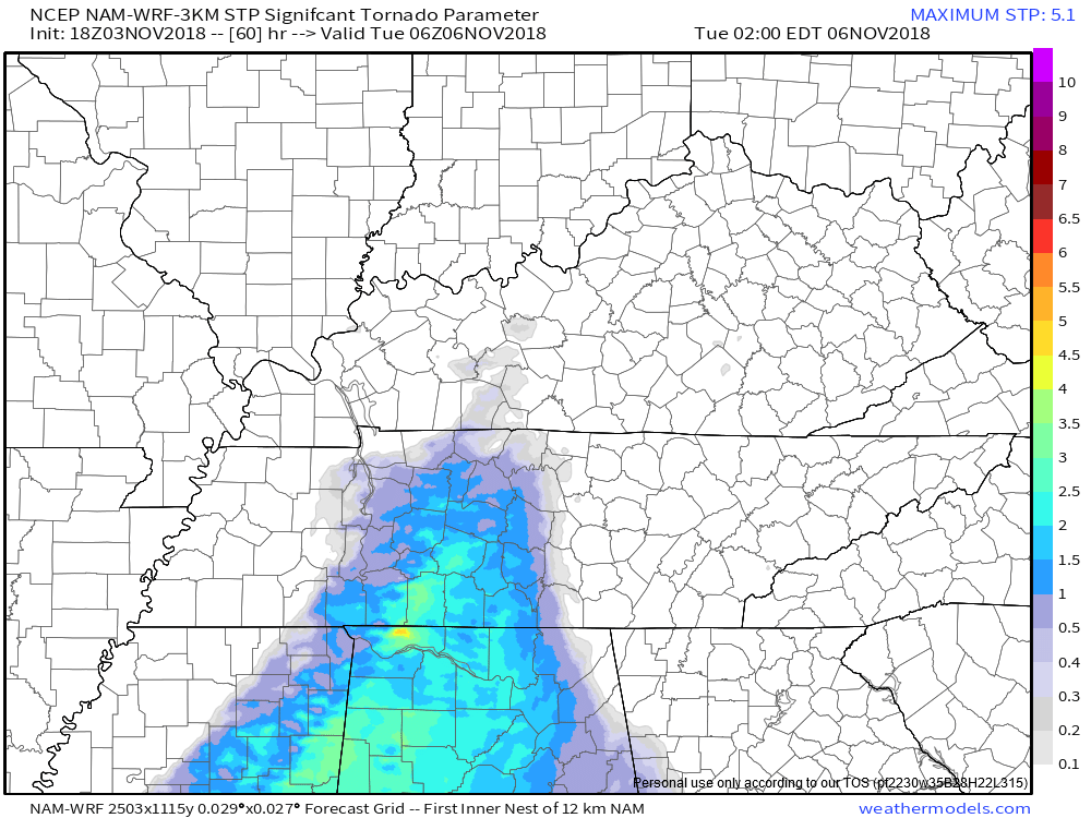
The NAM3 model has sampled (barely) the ETA of the line, but it has a pretty mild Significant Tornado Parameter score for us, a good sign for us:
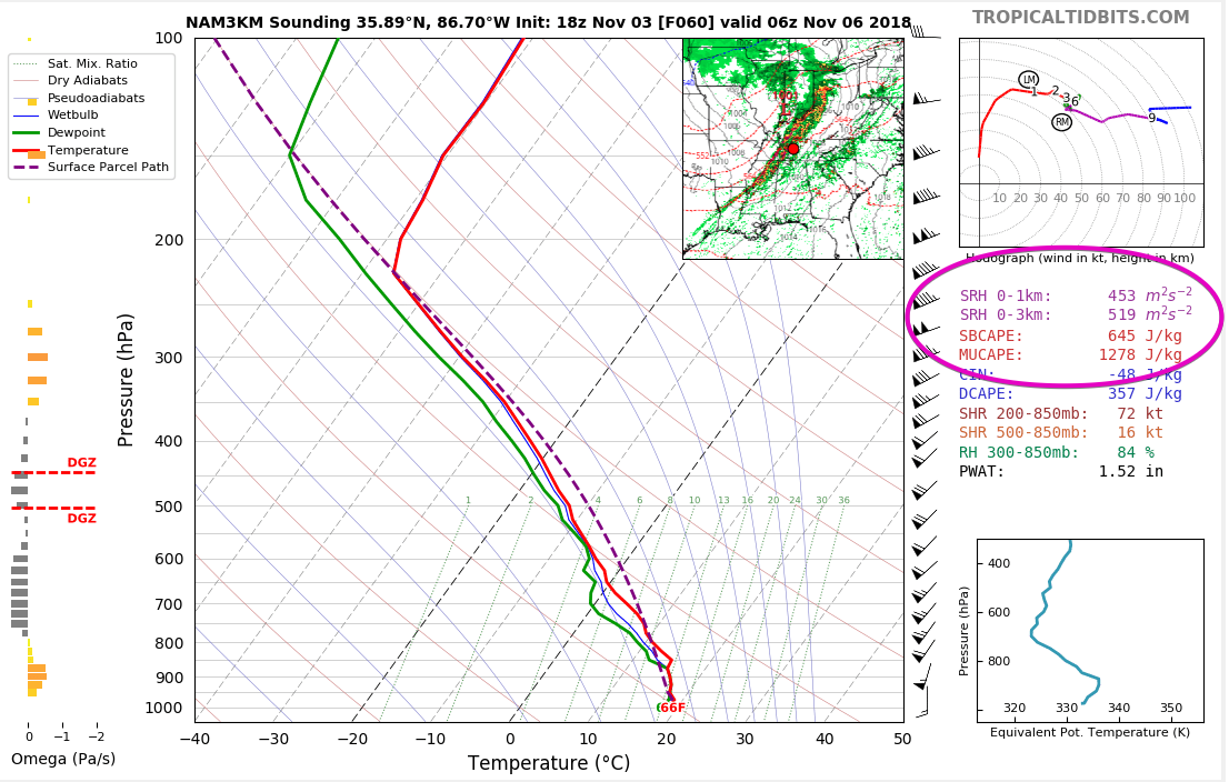
However, if you look behind the NAM3 model at the forecast sounding, yikes. The circled numbers = Do. Not. Want.
Same is true for the GFS model forecast sounding. We don’t want the atmosphere doing this, either:
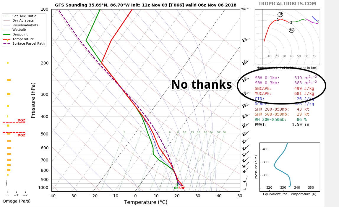
This has my attention.
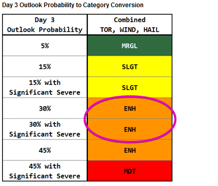
Confidence Levels
Right now this is a “regional” concern, which is to say no data is reliable or high-res enough to provide local specifics. As the event nears more specific and local information becomes available. So for now, the best way to assess risk is to examine probabilities from the Storm Prediction Center.
We are in an “Enhanced Risk,” which is on the higher side of ruh-roh-ness from the SPC for an event three days away.
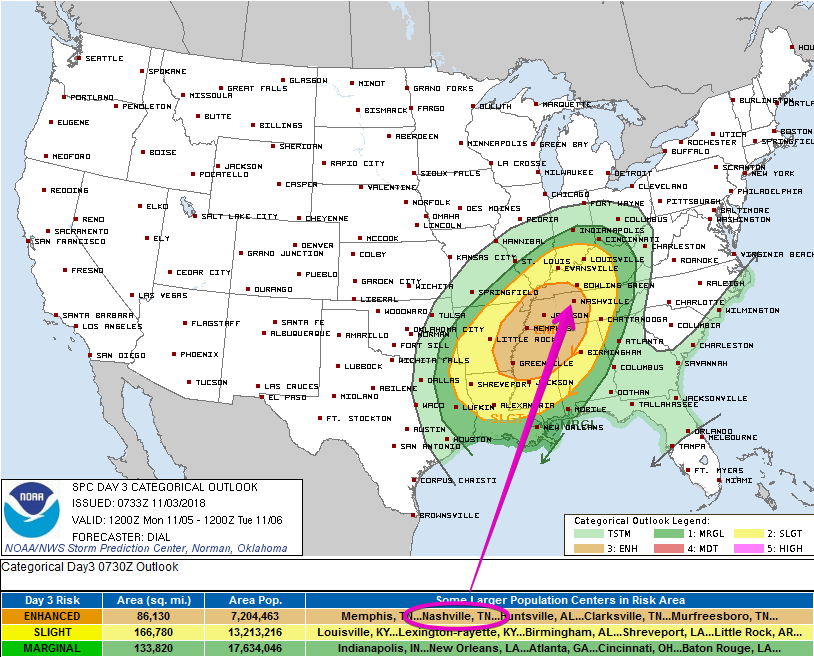
Three days away, this risk is here on the SPC scale:
Also, yes, that map looks like an avocado.
The companion SPC map below lays out the probabilities:
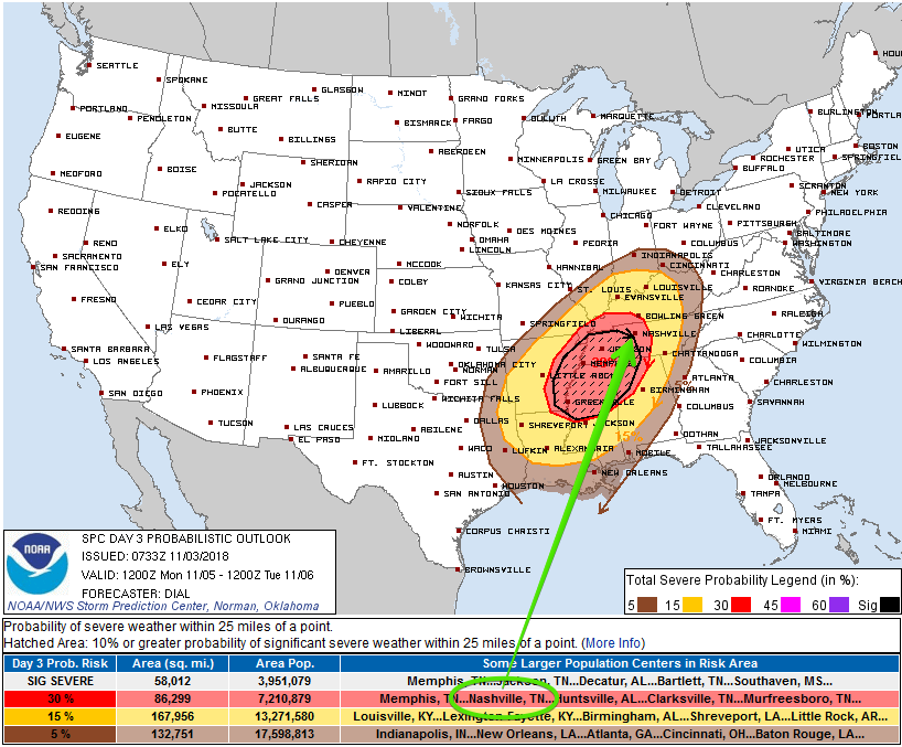
Our inclusion in the red-shaded area means SPC thinks the probability of a severe weather event (wind and/or tornado and/or hail) happening within 25 miles of you is 30%.
That uncomfortably-close-to-us shaded “hatched” area means the probability of a “significant severe” event (within that 30% area) is 10% or greater. “Significant severe” events include:
- A tornado that produces EF2 or greater damage.
- Wind speeds of 75 mph (65 knots) or greater.
- Hail 2 inch in diameter or larger.
These probabilities will be updated several times. The next update arrives while we sleep overnight tonight.
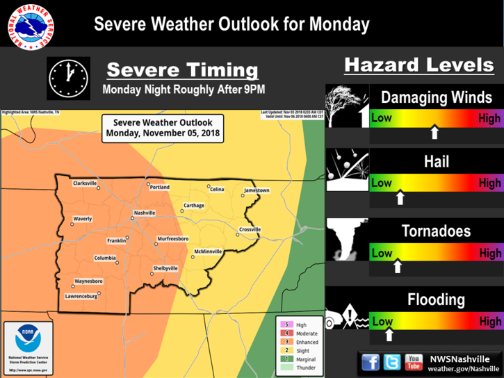
Damaging straight-line winds are the most likely mode of severe weather. NWS-Nashville’s graphic illustrates the relative risks:
Could this forecast “bust” and nothing bad happen? Yes! There are several ways that could happen. The usual way a forecast like this busts is by a lack of instability in the atmosphere. Right now, all weather models think we’ll have enough instability to cause problems.
Forecast “busts” have been common recently. The past few “Moderate Risks” (a 4 on a scale 0 to 5) were total non-events. We hope this repeats that. However, all model data thinks there will be enough instability to supply storms needed energy to go severe. We should not allow recency bias to disrespect this system. Tornadoes can — and do — develop in Middle Tennessee in November. That this system is coming in at night (without daytime heating) should not be much of a factor. Cold season severe weather systems bring their own booze to the party.
What To Do Now
Clean out your safe space this weekend – just in case. Even if this event busts and nothing happens, another storm event may be shaping up late next week.
In a mobile or manufactured home? Know where you’ll go now, don’t leave it to the last minute.
Got kids? Make them wear helmets in case of warnings. One horrible lesson from April 27, 2011, is that many injuries to children could have been prevented or reduced had kids been wearing a helmet. I’m a grown man and I wear one during warnings.
Also, remember your shoes! I have stood in major and minor storm damage, you need shoes.
Severe weather refresher — terminology, tips, safety — here.
Also if you’re one of those people who gets irate when the Titans game is interrupted to deliver potentially life-saving weather information to someone, plan ahead and figure out another channel (ESPN, streaming may be options) to watch the Titans game in case Channel 2 has to break in. I understand that the world revolves around your love of the Titans and nothing should get in your way, your majesty. I know you don’t care about someone else getting a warning if it means you miss another punt by the Cowboys, but be sure you have a way to get warnings. Jerry’s World may be tornado-proof. Not sure your house is.
Should You Panic?
Nope. Be prepared, stay informed, it’s more likely than not nothing will happen to you. You will probably be fine. But you should be ready and respect these storm systems.
Have a great weekend! Much more about this later today, Sunday, and Monday on Twitter and on this dot com.

Categories: Forecast Blogs (Legacy)
You must be logged in to post a comment.