This morning, the HRRR model predicted this afternoon’s showers and thunderstorm, which poked through high pressure like a hernia through a tummy.

If you were north of the 24/65 split, near Skyline and Madison and Goodlettsville, you could not ignore it. It tossed lightning and prompted NWS-Nashville to issue an Areal Flood Advisory and a Significant Weather Advisory.
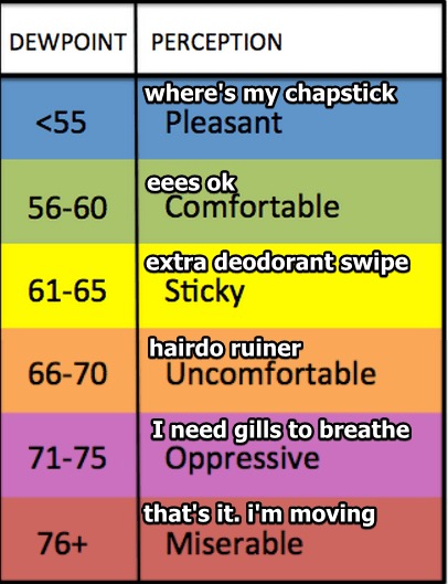
The dewpoint will stay around 70° all week, keeping humidity uncomfortable, but not quite oppressive according to the handy chart below.

With temps topping out in the low 90°s Monday and Tuesday, expect the heat index to reach 94° both afternoons. Probably hotter in the sunlight. That 94° heat index is for the shade.
Storms are unlikely Monday and Tuesday. Too much high pressure, but it’s possible one could squeeze out. The HRRR model thinks a few showers will try to come north up I-24 Monday afternoon, then fizzle before arrival.
Rain Chances Return Wednesday Night & Continue Thru the Weekend
By Wednesday, high pressure departs. A wandering, elongated, slow area of low pressure arrives for the rest of the week, bringing decent chances of rain as early as Wednesday afternoon, but more likely Thursday and Friday.
Currently the most likely time period for rain and storms is Thursday night.
Cloud cover will cut temps a few degrees, but it’s still going to be very humid. Without high pressure there to prevent all that humidity from lifting and becoming rain or storms, we should expect downpours at times.
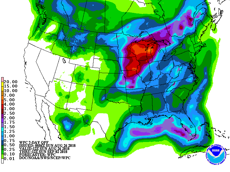
Models do not have a handle on specific timing, so I’ll leave it to your crap app to do the irresponsible speculation and guesswork. WPC’s “how much we think it will rain from now until next Sunday morning” has us down for total rainfall under 0.75″:

That’s not a much rain in a week. My educated guess is Sunday and Labor Day will be the usual “hot, humid, maybe a pop up storm” day we usually get in early September. Stay connected on that.
Stay connected for radar updates and new forecast information on Twitter @NashSevereWx (not on Twitter? Go here).
Categories: Forecast Blogs (Legacy)


You must be logged in to post a comment.