
Just sit back and imagine, rain-free, mid-upper 80º days in June… wait!

No need to imagine, that’s exactly what we are going to have most of this week! Just look at this:
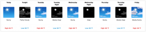
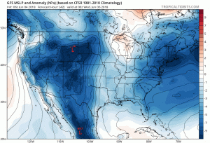
High pressure is centered over central Missouri this morning. It will eventually move into the Tennessee River Valley by tomorrow, maintaining near-normal temperatures with comfortable dew points.

A slight uptick in humidity is expected Tuesday night, along with a temperature increase in the morning and late afternoon.
This will begin a slow warming trend. A little warmer, a little more humid each day this week.
A very isolated shower or thunderstorm cannot be ruled out from Tuesday on, however, the chance is very low and hardly even worth mentioning.
The relief won’t last forever, unfortunately. We are already watching late week and the weekend for a ridge to push eastward. Nashville will be on the edge of the ridge, so scattered thunderstorms may occur in the afternoon and evening hours, beginning Friday and continuing through the weekend. Coverage of showers will increase each day through Sunday, especially in the mid/late afternoon and early evening hours.
Heat and humidity will be here in full force Friday, just in time for that music festival you may have heard about downtown.
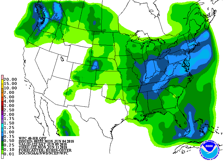
The Weather Prediction Center thinks we’ll see, on average, about a half inch of rain total this weekend, but rain in your actual backyard, field, festival spot will vary.
Stay clicked to NashSevereWx for any changes to the forecast (though, we feel pretty confident about this week)!

Categories: Forecast Blogs (Legacy)
You must be logged in to post a comment.