
Dry Weather!

We have finally hit a dry spell that will last for more than just 2-3 days! This time, we are going to be dry for the work/school week!
Temps Up & Down
Our temperatures, however, are going to be on a roller coaster.
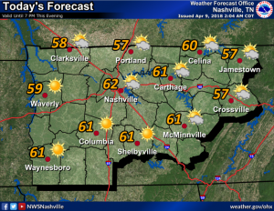
Starting with today, expect a high of 62º with a low of 39º tomorrow morning. Tuesday, we will get a dry cold front to move through the area, so we’re only expecting highs in the upper 50ºs. Then, Wednesday morning, we will flirt with freezing in Williamson and Davidson Counties with temperatures around 35º. After that, we are not expected to go below freezing, but it is not out of the question. And for Thursday and Friday, highs in the upper 70ºs!
Rain/Storms Saturday
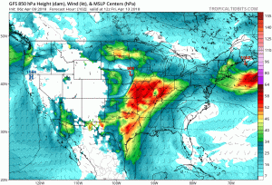
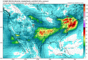
Our next rain/storm chance comes Saturday as a rather potent cold front is expected to approach Middle Tennessee. The timing for Saturday is looking to be uncertain with the GFS (above) showing rain and a few storms Saturday morning, while the European (below) shows rain/storms arriving mid-late day.
Severe weather remains uncertain at this point, however, strong storms are possible. The Storm Prediction Center expects strong/severe storms Friday to our west, but there to too many uncertainties Saturday to include us in a similar risk for Saturday. Models predict low “storm food” here Saturday. Keep checking back to NashSevereWx for this evolving forecast.

Cold Again Sunday
After the rain/storm-making cold front Saturday, highs look to return to the mid-50ºs and lows to the mid-30ºs. Hopefully this upcoming weekend will be our last time dealing with temperatures in the 30ºs, but as our partners at NWS Nashville said this morning, “No promises can be made just yet!”
Categories: Forecast Blogs (Legacy)
You must be logged in to post a comment.