
Current Radar
Review of the Morning Events
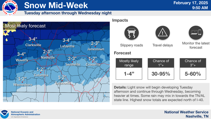
We went to bed last night expecting under 1″ of snow along and south of I-40, with no accumulating snow north of I-40, as seen here:
Friday's expected snow totals, via @NWSNashville pic.twitter.com/kO8z9Xv55H
— NashSevereWx (@NashSevereWx) January 6, 2017
This was supported by the GFS and European models. Some models had the snow missing us altogether. One model, the NAM, thought the snow would push further north than I-40. The forecast represented a blended solution between all the models.
At 2:31 AM, while hopefully everyone was still asleep, NWS-Nashville saw more than “under 1″” of snow coming, and issued a Winter Weather Advisory for 0.5″ to 2″ for Williamson County.
At 3:49 AM, NWS-Nashville updated its forecast for Davidson County/Nashville in a Special Weather Statement, calling for a dusting to 1″ for the snow that, at the time, had not even crossed the Mississippi River The message:
Radar at 3:52 AM showed the expected heavier snow along and south of I-40, plus a northern area of snow that was racing east out of Arkansas, which prompted the 3:49 AM updated advisory for Davidson County.
Memphis radar is very interesting this morning. A few pockets of snow advancing east: pic.twitter.com/CMKD3wWHBt
— NashSevereWx (@NashSevereWx) January 6, 2017
Around 5 AM, reports of accumulating snow were coming out of Jackson TN and SW Middle Tennessee, and it became increasingly apparent some roads in both of our counties were going to see enough snow to cause roads to become slippery and hazardous, as set forth in the statement issued at 3:49 AM.
As the snow entered both counties, dry air aloft ate some of it. But the Dry Air Monster was quickly filled to capacity, and the snow came to ground as the fast-moving system streaked in from W Tennessee.
At 5:25 AM, it was becoming apparent that with 0.5″ to 1″ expected in Davidson County and 0.5″ to 2″ expected in Williamson County:
The early commuter gets the worm this morning, y'all.
— NashSevereWx (@NashSevereWx) January 6, 2017
At 6:00 AM, NWS-Nashville upgraded all of Davidson County to a Winter Weather Advisory, raising the range of total snow from 0.5″ to 2″.
As I write this, the totals are 1.5″ in Fairview, 1″ in Bellevue, 0.75″ in Joelton, 0.25″ in Goodlettsville.
Morning Snow Tapering Off, *Maybe* Some More Tonight

Be sure to tweet us @NashSevereWx using #tspotter with any pictures of snow accumulation you have received thus far. Use a ruler on a hard surface to get an accurate measure of snowfall and don’t forget to tell us your location.
Winter Weather Advisory Continues Through Midnight Tonight:
And here is the text that goes with the advisory:

Note that the advisory mentions a “second round” to the snow. This second round will likely go east and south of us, but we could get a few more flakes before the night is over.
Since snow has also accumulated on the roads, be sure to slow down and drive responsibly the remainder of the day.
How Much Snow Can We Expect to See? The range is 0.5″ to 2″. More is expected the further south you are in Davidson/Williamson, less is expected the further north you are.
When Should the Snow Leave? We are tweeting regular radar updates @NashSevereWx on Twitter.
The first round (heavier and where most of our snowfall will come from) will likely stick around until the beginning of the afternoon.
HRRR thinks the snow will play out a little something like this:

If the second round plays out like the HRRR model thinks it will, most of the snow will likely go to our east, but nonetheless we could see a dusting of some more snow this evening. It should be much less than what we’ve already seen this morning.
Another one of our short term models, the NAM, seems a bit more “bullish” and has us receiving a bit more snowfall than the HRRR, but still not very much.

It appears that our first round will have more snowfall and will end a little after lunch. The afternoon through the early evening we probably won’t see any more snow accumulate, but our temps are cold enough that it won’t melt either. By mid-evening, we could see that second round of snow showers. We probably won’t see as much snow with it as we have this morning, but we could add a bit more snow to those snowfall totals.
Snow total/accumulation forecasts are always inexact and will likely evolve throughout the day, as they always do. Be sure to stick with us on Twitter @NashSevereWx and multiple local weather outlets for the most up to date information.
Next Several Days, Sunny Skies Will Prevail

Following our snowy couple of days will be a high pressure that will help to keep us dry over the next few days.

Temps over the next several days will remain below freezing and be extremely cold in the AM. Tomorrow morning, wind chill temps could reach as low as 0° while on Sunday morning our temps will reach down into the low teens. This will likely also be the coldest temps that we have seen all season up to this point.
As we head into Monday, temps will begin to rebound back above freezing.
Monday Night and Beyond – Showers Re-Enter the Discussion
Rain returns to the forecast during the overnight hours on Monday.
Right now our models look a little something like this, with the better chance of rain coming Tuesday night into Wednesday.

Looks like we will get some rain again by mid next week. NWS Nashville also had this to say about what to expect next week:
“At the very least, it looks like warmer temperatures will stick around and the threat of wintry precip will hold off through next weekend as well.”
This website supplements @NashSevereWx on Twitter, which you can find here.
Categories: Forecast Blogs (Legacy)
You must be logged in to post a comment.