
Current Radar
Tonight: Windy, Rain Arrives After Dark – 9PM 54°
The wind machine remains “on” this evening out of the northwest, 10-15 mph gusting to 20 mph. These winds should finally settle down overnight.
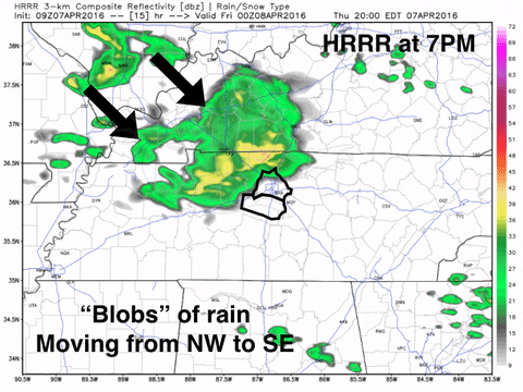
Our best rain chances come towards nightfall. Check out the HRRR model below:
These showers will be nothing spooky, just friendly rain “blobs”.
UPDATE: Take the rain jacket! Here’s a newer run of the HRRR at 7PM, which says rain by sundown…

Temperatures will fall into the 50s by 9PM, and then drop into the 40s overnight into Thursday.
Friday: Pesky Showers, Limited Sun – Wake Up 41° High 58°
Temperatures will struggle to make it into the upper 50s, so it might be nice to have a jacket if you’re headed outside. Also, northwest winds at 10-15 mph will gust as high as 30 mph in the afternoon.
Using extra hair gel or hairspray might be a wise choice.

Pesky rain showers may hang around for a better part of the day.
Here’s an example of what these small rain pockets may look like:

Nothing very substantial.

It’s going to get cold overnight Friday into Saturday…
Saturday: 100% Sun, Chilly Temperatures – Wake Up 34° High 53°
You’ll be lucky to find a cloud, and if you find two, you’re probably a magician.

Highs Saturday afternoon will top out in the low-to-mid 50s, so definitely jacket weather all day long.
UPDATE: There is the potential for a widespread frost overnight Saturday into Sunday morning, with some freezing temperatures possible. These conditions will be more prevalent on the outskirts of downtown Nashville.

Allergy Report:
Keep those allergy meds nearby! Otherwise, the 5-Day pollen.com forecast says you could be sneezing a lot:

Extended Outlook: Warmer Sunday, Early Week Storms
It looks like Sunday is your best day to get outside and enjoy warm temperatures with a smidgen of sun. Storms are likely to start the work-week next week.

This website supplements @NashSevereWx on Twitter, which you can find here.
Categories: Forecast Blogs (Legacy)
You must be logged in to post a comment.