
Current Observations and Radar (refresh to update)


Warming Up
Yesterday and today, we hit 84° (we may have snuck in 85° today, waiting for official word on that). Tomorrow and Friday we’ll hit 88°, with 87° on Saturday.
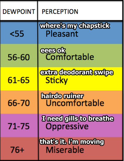
Dewpoints will rise to Sticky levels Friday & Saturday, which may require an extra deodorant swipe. Please consult this handy table:
Wee Hour Fog
Possible in the early morning hours Thursday and Friday. Watch out for it in the usual spots.

Weekend Rain? Prolly Not
We’ll be dry through Saturday.
A cold front will arrive Sunday. As usual, this means rain is possible. Except this time, the front is a wuss.

Euro and GFS models still think the front will pass with little to no rain, so for now we think the chance of rain is brief, and low. The front may only accomplish making some pretty clouds, admired in its time, then forgotten by history.

There is more model support for rain on Monday, but we’re talking about 144+ hours from now, and forecast accuracy that far away is (alert! repeat GIF!)

The cold front will trim the top off the temps. Low 80°s return beginning Sunday.
This website supplements @NashSevereWx on Twitter, which you can find here.
Categories: Forecast Blogs (Legacy)