
Current Radar
The weather today and tomorrow will defined by the heat and the storms. So, we’ll dispense with the usual format accordingly.
The Heat – High Today 95°, Tuesday 93°
Afternoon heat index values will range between 100° to 105°.

Storms Tonight (Probably Late)
As you can see below, the first big hairy line of thunderstorms is trucking through the Ohio Valley:

The HRRR model thinks that first big hairy line will continue to move SE, and miss us, passing to our east:

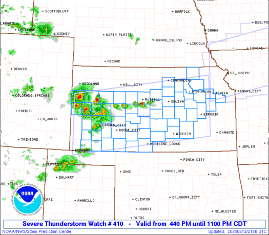
SPC has already tossed up Severe Thunderstorm Watches in the area that big hairy line is headed:
You’ve probably noticed the storms developing to the west of the aforementioned big hairy first line.
That’s where the main show will be.
The latest info from the Storm Prediction Center is basically unchanged from what we saw earlier this morning.

The worst part of the storm system is still expected to move southeast through the purple area:
Damaging thunderstorm winds remains the biggest concern. The shaded (“hatched”) area denotes a 10% or greater probability of wind gusts 65 knots or greater, which is basically Category 1 hurricane strength (note: if this happens, these will be gusts, not sustained winds experienced in hurricanes). Early this morning, we were sitting on the edge of that area:storm wind gust of 58+ mph, it’s always good to see the hatched area get moved off you. It’s still pretty uncomfortably close, if you ask me.
In fact, a derecho is possible. To qualify as a derecho, you need a thunderstorm complex producing a damaging wind swath of at least 250 miles, producing 58+ mile-per-hour winds almost continuously for at least six hours.

The first big hairy line looks like it’ll go east of us.
As for the other stuff, after midnight is the best thinking.
Notice how SPC cuts off the hatched area at the KY/TN line. This may reflect thinking that the event will be breaking up by then, and the models, which have been very little help, support that.
However, we remain in that 30% probability of a damaging wind event, and a 5% hail with a 2% tornado risk.
We’ll be tweeting @NashSevereWx throughout the day as new details/information arrives.
Storms Tuesday Afternoon
As the risk for severe weather shifts east, we remain on the familiar edge of that risk:
For Monday, we will see the storms coming from 100s of miles away. Not so Tuesday.
Tuesday’s threat includes:
1. Supercells capable of destructive hail.
2. Some potential for tornadoes, while not ruling out strong tornadoes.
The ETA for this is after noon.
The good news for us, but not for our neighbors to the east, is that it appears the dynamics are going to be better for severe weather east of I-65. Don’t bet on that, though. This area is subject to revision by the Storm Prediction Center several times before the weather is expected to arrive.
Extended: The Heat Stays
This website supplements @NashSevereWx on Twitter, which you can find here.
Categories: Forecast Blogs (Legacy)