
Current Temps and Radar

Below is the satellite image from just before noon today. There were no clouds in the sky. That’s snow on the ground:
It’ll be interesting to see how much snow is left to our west tomorrow. Temps ran into the 40°s over most of it.
We made it to 60° (!!!) today.

Sunday – Moisture/Clouds Increase – Wake Up 32°, High 57°
A warm front will arrive late Sunday night, shifting us into a cloudy, rainy pattern expected to continue all of next week.

There’s a slight chance of a few showers Sunday night.
Monday – PM Rain – Wake Up 39°, High 57°
The first of a series of waves approaching from the South and Southwest should arrive late Monday afternoon/evening, delivering rain and ruining the dryout we’re getting this weekend.

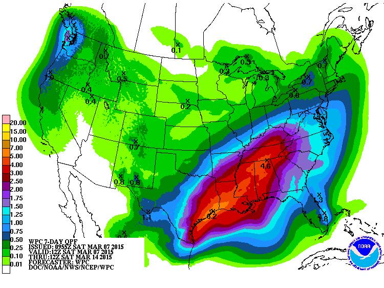
The pattern is wet all week, no consolation for area soccer and baseball players. The rainiest periods will be Monday night and Thursday night. Through the end of the work week, between 3″ and 4″ of rain is expected.

We’re in the beginning of severe storm season, but nothing is showing up severe-wise over the next 8 days. The first chance of thunderstorms shows up Saturday afternoon. As in a week from now. Needless to say, our confidence in that forecast is low.

This website supplements @NashSevereWx on Twitter, which you can find here.
Categories: Forecast Blogs (Legacy)