
Current Temps and Radar

Let’s start with an overview:
That’s pretty blerg.
The Blerg looks like it’ll break after next weekend:
Today – Little More Melting (High 39°), Cloudy, Chance of Rain/Snow Tonight
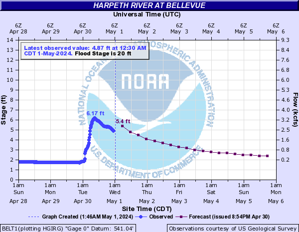
Rivers and streams are still rising a bit. The Harpeth River at Bellevue got a Flood Advisory early this morning water levels moved into action stage:
A Flood Watch remains until noon today.
Over the next 2 or 3 days, rain systems will pass to our south. Some of them may wander north into Middle Tennessee.
The first of those comes tonight/overnight.
There’s low confidence in this snow. If the system passing to our south wobbles south at all, we won’t see anything. This is very light precip. It would only be a “very light nuisance” per NWS.
Monday – Below Freezing – Wake Up 19°, High 29°
Wake up wind chills Monday morning will be in the single digits, and won’t warm past the teens all day.

24 hours after Sunday night’s iffy snow event, an almost identically iffy/light snow event is possible:
Friday-Sunday, the following pattern is possible:
1. Rain/Snow mix at night.
2. Transitioning to light snow after midnight.
3. Then transitioning to rain during the day.

This website supplements @NashSevereWx on Twitter, which you can find here.
Categories: Forecast Blogs (Legacy)