
Current Official Hourly Observation (taken at :53 on the hour)

Current Radar Loops
![]()
Temp & Rain Probabilities Next 36 Hours (auto-updating)
Severe Weather Possible Tonight
The latest (8 PM) outlook from the Storm Prediction Center trimmed back — but did not eliminate — our severe chances tonight.
Despite dewpoints in the low 60s (plenty high enough to fuel storms) today, a “cap” aloft (temperature inversion) has prevented significant storm development today.
The cap is now gone (arguably there’s a tiny one at 850mb) according to the 7 PM weather balloon:
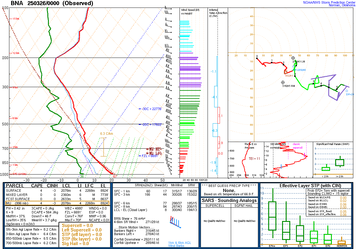
These are impressive, but not “hide the women and children,” severe parameters. The good news is that we should see those parameters decrease a little more later tonight.

Storms to our west are expected to form a giant squall line, whose main feature will be damaging straight-line winds. When the squall line arrives, the probability of it packing 60+ mph wind gusts within 25 miles of you has, as of the 8 PM update from the SPC, decreased from 30% to 15%:
In addition, upper atmospheric dynamics will support intense updrafts conducive to large hail formation. The probability of large hail falling within 25 miles of you decreased, at the SPC 8 PM update, from 15% to 5%:
Although damaging straight-line winds and large hail are the main threats, one or two tornadoes are possible along the squall line. We cannot rule them out. The probability of a tornado occurring within 25 miles of you remains at 5%:
The hazards remain:

The squall line will arrive so late, it’s probably more accurate to call it “early.”
The ETA remains between 3 AM and 7 AM:

The HRRR thinks we’ll see the line at 4 AM.
This “wee hour” ETA will aid in the overall weakening of the squall line compared to the punch it will pack in Arkansas and West Tennessee. The above-described hazards and probabilities take the weakening into account. Stated another way: despite the fact it will have weakened, the possibility of severe weather remains.
Consider getting a wake-me-up app (see the above banner) and/or a NOAA weather radio. It’s possible a Tornado Warning may be issued while you sleep. Charge your phones. Have helmets for kids. Have shoes nearby. Get to the lowest level of your home, and shelter in an interior, windowless room. Yes, this is a hassle and the odds of a tornado hitting you are small, but — and feel free to disagree — I think your safety is worth a half hour to 45 minute inconvenience. #EndOfSermon
The storms should clear before noon Friday. Expected rainfall estimates continue to decline; currently, rainfall totals are forecast to be a little under 0.5″, which is excellent news for those hoping to get in your [ball must roll on the ground] game Saturday. Davidson County should see an additional 0.45″, Williamson County an additional 0.47″. Totals in your backyard will obviously vary.
Winds behind the squall line will be strong, sustained at 19 mph, with gusts in the 20s. We’ll hit 70 tomorrow afternoon, then winds will slacken off after sunset.
The weekend will actually be nicer than this graphic suggests:
Do NOT rely on this website for severe weather watches and warnings. This site supplements content found on Twitter @NashSevereWx. Monitor multiple reliable weather sources, and heed all warnings.
Categories: Forecast Blogs (Legacy)