
Remember this?

Lucy tells Charlie Brown she’ll hold the ball, only when he comes up to it, she pulls it away? Looks like this may be happening to the sled-able snow we thought we could be getting early this morning.
(The above gif idea came from the weather forum tennesseewx.com. Full credit to “bugalou” for posting it).
It’s all a big “maybe.” Rather than snow, we will probably see a mixed bag of wintry precip, culminating in an “unfrozen slush.” Keep reading.
Our NWS, speaking about all of Middle Tennessee, had this to say just after 11 a.m. this morning:
We believe the main impact will be an unfrozen slush during the afternoon and evening hours, but then transitioning to a more dangerous period later in the evening and overnight (especially on untreated bridges and overpasses) when temperatures fall into the 20s and remaining moisture could easily freeze and produce patchy black ice.
Officially, for Davidson & Williamson Counties, our NWS opens a rain/sleet/snow window beginning at 3 p.m., and closing around 9 p.m. Snow is more likely between 5 p.m. and 8 p.m. It all should all be over well before Wednesday morning.

Then there’s the HRRR.
The HRRR is a short-range weather model. It’s not perfect, but I respect it like Alabama fans respect Bear Bryant. It updates every hour, bringing us a fresh batch of data of what it thinks will happen over the next 15 hours.
Early this morning, the HRRR predicted a healthy snow starting around dark; however, several runs mid-morning pulled most – but not all – of the precip east before the snow-making temps filtered in. This does not mean we will get nothing, but I’d put away my sled (it’ll be dark, windy, and no fun).
Here’s the latest (15z) run of the HRRR, from noon until 9 pm tonight (green is rain; blue/red is snow):
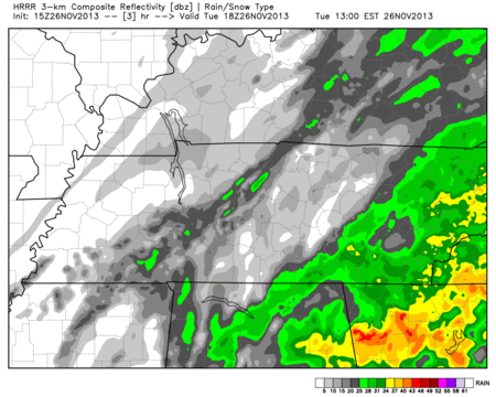
This is not an impressive snow event, but it’s not nothing. In fact, the HRRR even has another little strip of snow coming through at midnight.
Other weather models (like the WRF) wrap in some snow along and east of I-65 tonight. Others (like the NAM) have it snowing juuust off to our east, missing us completely. This is a very, very close call for us.
Travel issues are possible, if not likely, tonight. Temps are going to crash below freezing after 6 p.m. A strong north wind will drop wind chills into the upper teens (officially, the wind chill is forecast to be 17 at 9 p.m.). Anyone going east on I-40 should pay particular attention. If you can travel out that way tomorrow, that may be better.
Our Winter Weather Advisory remains in effect:

Do not rely on this webpage as your only source of updated info. Brand-new information will be found on Twitter @NashSevereWx. As always, consult multiple weather sources before making decisions.
Categories: Forecast Blogs (Legacy)