
Tonight – Light Rain – Overnight Low 44
A cold front is pushing light rain across Middle Tennessee. Expect around 0.38″ in Davidson/Williamson Counties.
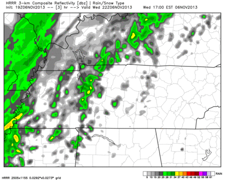
Here’s the HRRR model’s prediction for Wednesday 4 PM – Thursday 2 AM:
Rain will end a little after midnight. Cooler temps will slowly filter in behind the front.
Thursday – Cooler & Sunny – High 55
7a 45 . 10a 51 . 1p 54 . 4p 53 . 7p 45 . 10p 41
Grab your jacket.
Friday – Clear & Cool – Morning Low 33, Afternoon High 57
7a 36 . 10a 48 . 1p 55 . 4p 54 . 7p 47 . 10p 42
With the clear skies, low humidity, and calm winds, temps will drop near freezing in the morning, then rebound nicely in the afternoon.
Weekend – High Temps in the 60s
Clear, warmer, and no rain! A nice November weekend.
Middle Next Week – Rain Chances Return?
A building ridge of high pressure (usually associated with calm weather) will settle in over the next several days.
Low pressure (often associated with rain/disturbed weather) usually bounces off (or, is blocked by) those high pressure systems.
[Warning! The Editor Is About To Rant]
If all goes right (or wrong, depending on your point of view) next week, a low pressure system could pass juuuuust to our north, and possibly clip us with some precip next Wednesday:
The GFS model Wednesday 6 am – Wednesday 3 pm:

The ECMWF model spit out SN-W in Kentucky with this system. As we RTed today from Ryan Maue, who has an awesome weather models website (weatherbell.com), there may be a minor sn-wmaker in KY:
So, if you hear it’s going to sn-w “next week” on the internet, or from your Aunt Sue, remember the following:
1. A sn-w forecast over 7 days out, based on one model (and only one run of that model), has as much value as my prediction of the score of the Super Bowl in February (Bengals 27, Seahawks 19). Sn-w is exceptionally difficult to forecast 12 hours away, much less 180 hours away.
2. The models have not, and do not, say it’ll sn-w here in Tennessee. The ECMWF has it in Kentucky. The models have not been consistent with each other.
3. It may not even rain here, much less sn-w.
4. A mid-November sn-wfall would be exceptionally unusual.
It’s fun to watch the models, and wish-cast. Typically, I would ignore this, but I think it’s fine to talk/blog about it, as long as we qualify what it means, and what it doesn’t.
Categories: Forecast Blogs (Legacy)