
Tonight – Mostly Clear – High 82
A few more light showers can’t be ruled out tonight. But, because of the rain earlier today, we think we are probably done with rain/storms.
Wednesday – Random Rain/T’Showers Possible – High 87
7a 72 . 10a 79 . 1p 86 . 4p 87 . 7p 83 . 10p 76
There could be some fog developing in the early morning.
Much like Tuesday was, there is a chance for afternoon scattered showers/thunderstorms.
This is the Hi-Res NAM model interpretation of tomorrow (Wednesday) 8 AM – 5 PM:
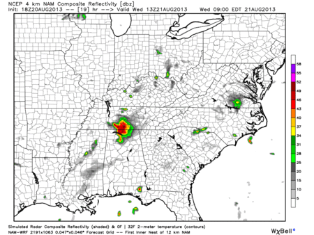
7a 72 . 10a 82 . 1p 89 . 4p 90 . 7p 86 . 10p 78.
A high pressure system is driving up our temperatures, which may actually help suppress pop-up showers/thunderstorms. Don’t expect this forecast to chance over the next few days.
Explanation of Forecasting Pop-Up Thunderstorms
Some of you may think that today’s forecast was blown, especially if you were caught in the rain. In reality, the forecast was pretty spot on. Our NWS gave us a 30% chance of showers/thunderstorms. During the Summer months we have a 20% – 40% chance of rain just about every day. For today and like most Summer days, there was confidence that is was going to rain somewhere in Middle Tennessee. So, why can’t we tell you if it’s going to rain, yes or no?
Try this: take a piece of junk mail and tear it up into about 10 pieces, then pick a place to throw them. Can you tell me exactly where each piece of paper is going to land? Of course not! But you know they will land in the general area you threw them. Those pieces of paper represent pop-up showers/thunderstorms during the Summer. Some stay dry; others get hit.
Meteorology has not yet figured out the pop-up thunderstorm.
Categories: Forecast Blogs (Legacy)