
The Setup
Whoever is doing the rain dance, did it right! Blame a “cutoff low” spinning in the middle of the country. It should rain out most – if not all – of the entire weekend.
So what is a cutoff low? It’s a low pressure system that has been “cutoff” from the flow of the jet stream (upper level winds) which push weather systems around. Since the low pressure system is cutoff from what steers it, it will just meander over the next few days, sending waves of rain our way. Until another system comes along and shoves it into the Atlantic Ocean, we are stuck dealing with it.
Rain will arrive tonight around 6pm – 7pm, plus or minus a few hours.
There’s a Wind Advisory in effect until 7pm tonight. If you’re going out tonight, the wind might tear up your umbrella.
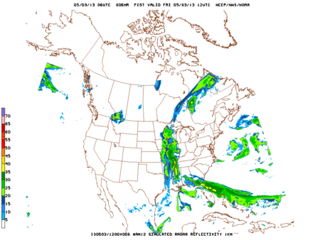
Loop of the high Res-NAM starting Friday at 7 AM through Saturday at 10 AM:
Totals
Here is what the Weather Prediction Center for rainfall over the weekend. Most of this will fall Saturday.

Past Rainfall
In the month of April we ended up 3.63” above our average of 4”. Check out how much rain we have received over the past 30 days :

Compared to average:

Flooding
With the amount of rain we got last weekend, flooding is a concern. The NWS has issued a flood watch:

Last weekend, the rain came in spurts. It was using warm Gulf of Mexico moisture. This weekend, the rain will be more slow and steady, and its source is not the Gulf moisture, but the cutoff low. Hence the much cooler temperatures.
Rivers
We will update river levels throughout this weekend.
Here is the forecast for the Cumberland River at Nashville, still below flood stage. However, this is based on forecast rainfalls – if more or less rain falls, it will change accordingly.

We do not expect a May 2010 flood; however, any flood is concerning. Flood is the #1 weather killer. Also note tomorrow’s temps will be much colder than it was last weekend.
Stay tuned here (for general forecasts) and follow us on Twitter @NashSevereWx (for more specific, frequent updates).
Categories: Forecast Blogs (Legacy)