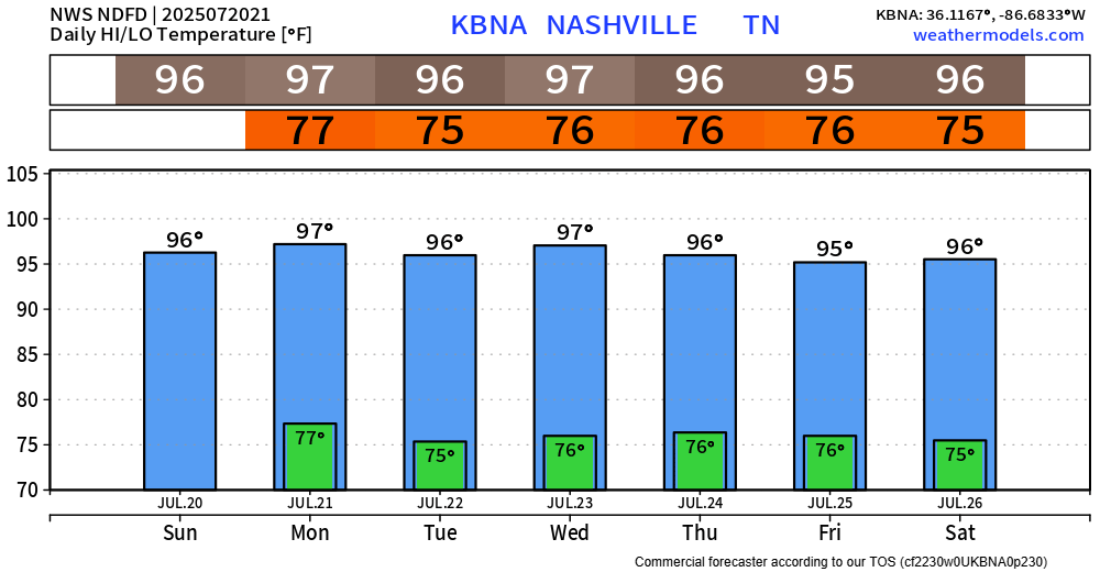
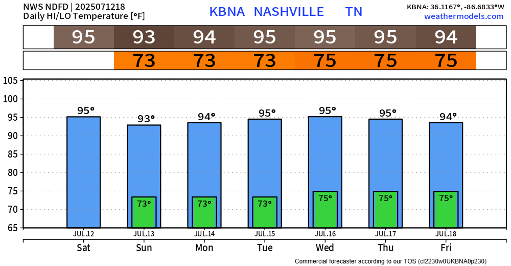
Main story this week weather-wise will be the consistent heat.
We have another Heat Advisory from 11a to 8p Monday, along with the one that expires at 8p tonight.
Heat index values up to 109° will be possible.

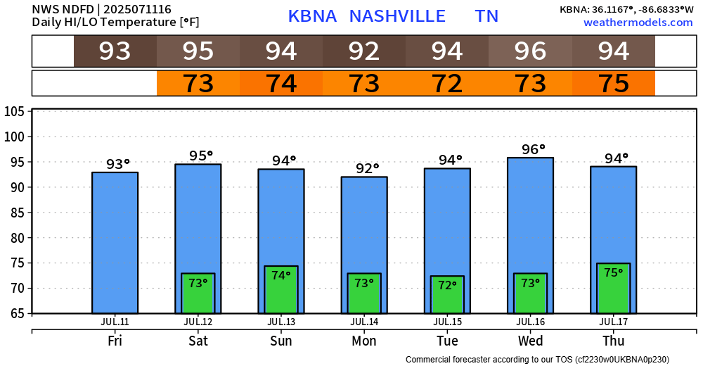
Main story this week weather-wise will be the consistent heat.
We have another Heat Advisory from 11a to 8p Monday, along with the one that expires at 8p tonight.
Heat index values up to 109° will be possible.
At the time of writing (4:30p), we are currently watching a line of storms that’s in KY and slowly moving south. It’s unknown if this will make it all the way here – but it’s something worth watching. Any severe threat is very low, and the main concern will be the potential for isolated flooding (especially those that saw heavy rain yesterday), frequent lightning and gusty winds.
Several showers and storms are out there tonight, being sparked off by outflow boundaries. If you have outdoor plans, keep an eye on the radar – when thunder roars, go indoors. No severe worries, but heavy rain (w/ isolated flooding), frequent lightning and gusty winds all possible. Some will stay totally dry.
Although we have missed out on any showers or storms so far today, the HRRR model has been consistent with the thinking that somewhere in Middle TN will see some storms closer to sunset. Something to keep an eye on if you have any outdoor plans this evening. You can check the radar on our website anytime right here: Radar | Nashville Severe Weather
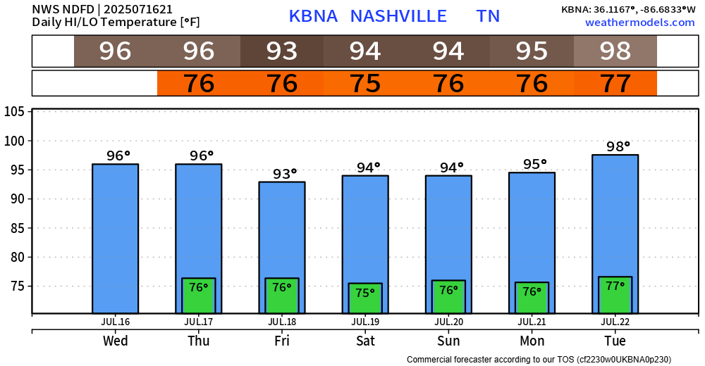
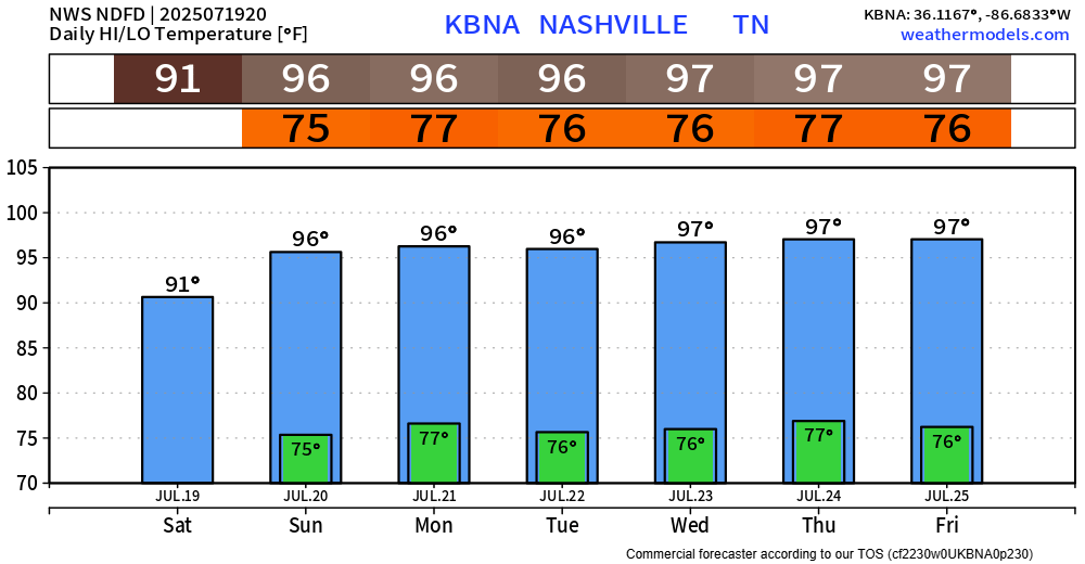
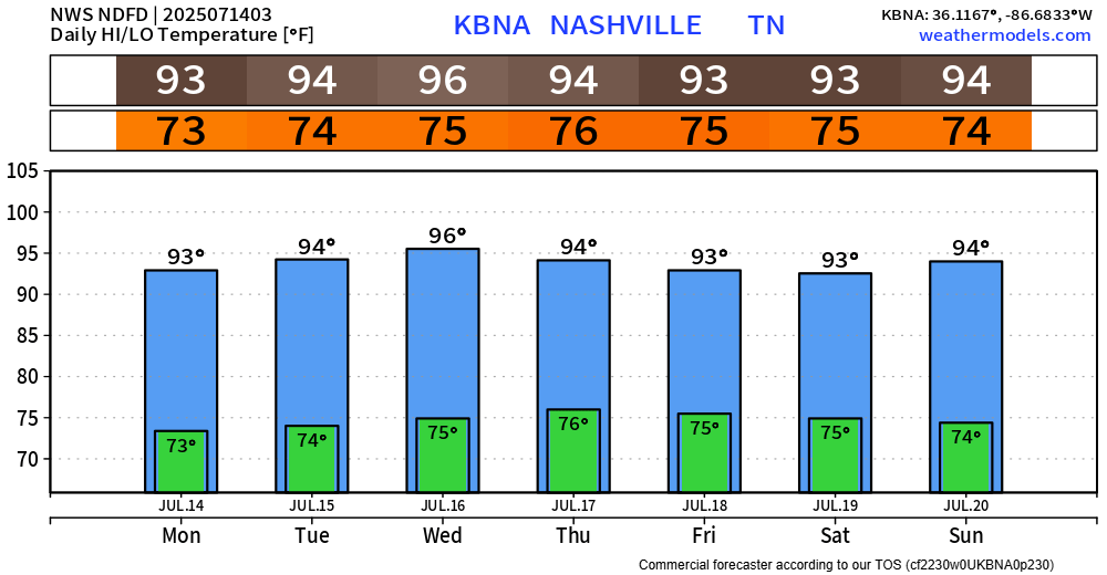
The upcoming brutal heat continues to be the headline of our forecast.
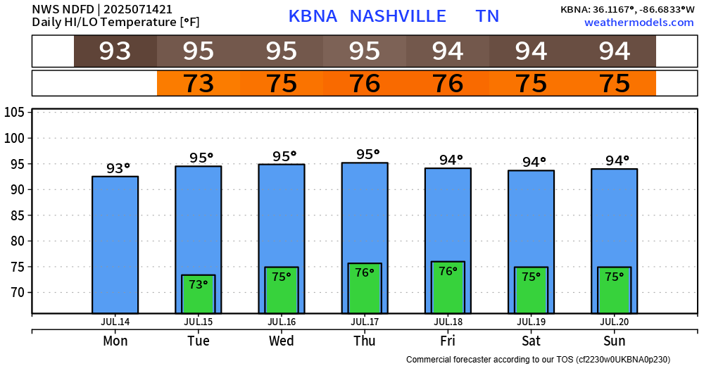
NWS Nashville has gone ahead and issued a Heat Advisory, valid from 12p – 7p on Thursday.
Heat index values up to 107° will be likely.
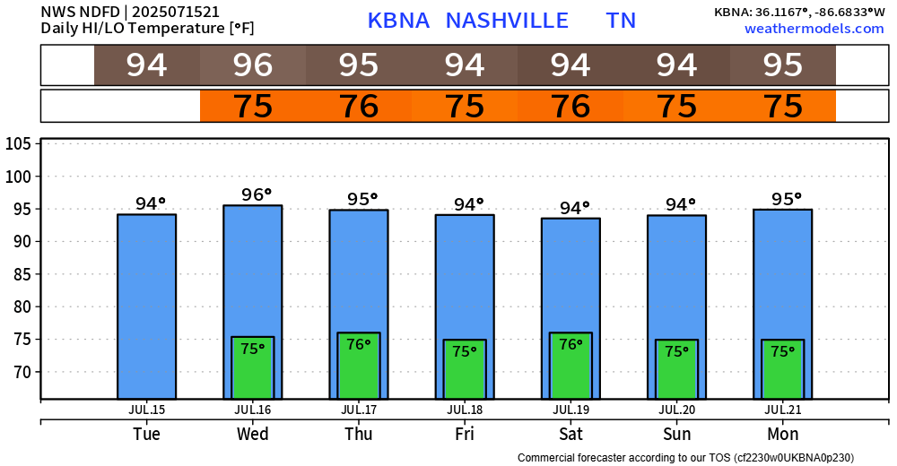
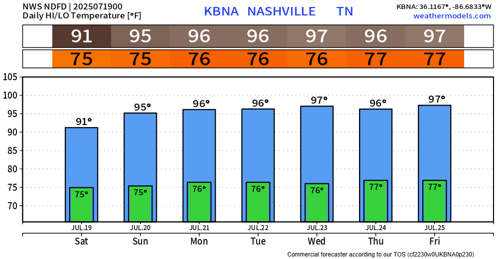
The main highlight of the upcoming forecast will be the heat.
The graphic below from NWS Nashville is valid for Wednesday but can really be applied to most days this week.
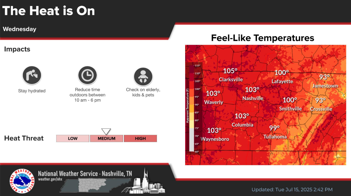
Our high temps will stay fairly consist in the mid 90s, while our dewpoints creep up into the mid 70s. This is a gross combo and will send our heat index values (“feels like”) near 105°. This is right around the criteria for a Heat Advisory, so while none are currently out for us – I wouldn’t be shocked if we saw one a day or two.
Last week’s weather continues on into the new week.
Low to medium chances for showers & storms continue daily, with chances being highest from midday thru early evening.
Some days you may see no rain, others you may see a little too much rain – like those near Hermitage today. Isolated flooding continues to be our main threat, along with frequent lightning and gusty winds. If you encounter a flooded roadway – turn around, don’t drown.
I won’t beat around the bush here. We’re stuck in the same pattern we dealt with all last week, really no other way to put it.
Low to medium Wattery chances exist daily this week, most likely from midday thru early evening.
We will continue to try and dodge rain and storms for the foreseeable future. Medium Wattery chances are in the forecast daily thru at least the end of next week.

Unlikely you see rain every day; most will probably stay dry. HRRR model thinks everyone stays dry today (Saturday), with better chances at a storm on Sunday.
I know I sound like a broken record, but most of the forecast really has been a copy and paste. I promise I’m trying to find different ways to say it so you don’t get too bored.

Over the next 7 days, we continue to deal with our daily Wattery chances – most likely from the late morning thru early evening hours.
You must be logged in to post a comment.