
1049 AM UPDATE: Last two HRRR model runs show a brand new potential concern: mid afternoon supercells somewhere in Middle TN which could produce tornadoes. This was not in the forecast (or in any of the data) this morning, so take it with a grain of salt. We don’t hide data from you. Takeaway: pay attention to the weather ALL DAY, not just tonight.
Headline: A Tornado Outbreak is expected in eastern Arkansas, west Tennessee (including Memphis and Jackson), the MO bootheel, and western KY today and tonight.
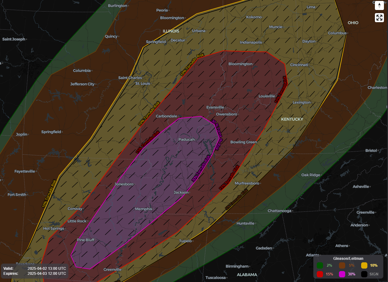
“Tornado outbreak” is not a lightly used phrase for us. People shouldn’t throw it around. Today, it’s appropriate. We use it because the Storm Prediction Center did:
A tornado outbreak is expected today and tonight from parts of the lower Mississippi Valley into the Mid-South and lower Ohio Valley. Numerous tornadoes, along with multiple EF3+ tornadoes, appear likely.
SPC Day 1 Outlook 7:48 AM 4/2/25
What this may mean for you.
- Before the storms: Wind Advisory. Gusts to 45 coming from the south, blowing north. You’ll feel it when you’re perpendicular to the winds on 840, 40, parts of Briley Pkwy, etc. Be careful driving your vans and trucks.
- The Big Storms Develop Out West. West Tennessee is in a rare “high” risk area — the highest level of concern the Storm Prediction Center can issue. That threat should arrive mid/late afternoon in Arkansas and move into west Tennessee by late afternoon/early evening. AVOID WEST TENNESSEE TODAY. Call your family and friends out west and let them know this is no joke.
- The Line Arrives Here “Weaker,” But By How Much? That’s the big question. First we have to estimate when the storms will get to us. The last eight runs of the HRRR model at 11 PM tonight have the storms west of us, moving our way. Other high res models agree. For now — and check back later because this could change — we think the rain will not affect your outdoor plans/games tonight, other than it being very windy. Planners should be sure to terminate games to give people time to get home, settled, and ready for what looks like another overnight event. The line will continue to crawl toward us as the system itself starts to stall out. This will not be like what happened Sunday night, when the storms passed through us and kept on trucking east. The HRRR model thinks the storms will arrive around/after midnight with plenty of storm fuel (CAPE), sufficient shear, and most of the ingredients needed for tornadoes. HOWEVER! As the system gets to us, it may fall apart right on top of us. The data is inconclusive about whether the system will carry tornado-making ingredients all the way to Davidson Co, to Williamson Co, or whether it’ll nerf out to our NW. The one thing we are sure about is that, relatively speaking, the danger is higher the further NW you are, and lower the further SE you are. But it’s way too close for comfort.
- So What Does All That Mean? You need to be ready to shelter for tornado in the event a warning is issued tonight, estimating between 10 PM and 3 AM, most likely between midnight and 2 AM, assuming all this comes together. SPC says the probability of a tornado within 25 miles of you is 10%, which includes potential for strong tornadoes. You need a wake me up app (like StormWatch+), a NOAA weather radio, and turn off your “do not disturb” setting on your phone.
- This Timing May Be Wrong! Check Back Frequently For Updates! Some data suggests the front will stall out further to our west. Some has it stalling out over Nashville and leaving Williamson Co alone. Some model data brings the threat into both counties. Models are never 100% right, but they’re useful. We’ll see this event develop and approach from far away and make revisions to the ETAs and threats/hazards accordingly on our socials (X, Insta, Blue Sky, Threads). Yes, hail is possible, along with damaging straight line winds.
- My Anxiety Level. I’m alarmed for West Tennessee and others in that High & Moderate Risk areas. I’m especially concerned for our brothers and sisters in mobile and manufactured homes. My anxiety level for us is kinda meh… for now. Too many questions need to be answered. But know this event has everyone’s full attention, especially tonight as it shows its teeth and creeps our way.
Elan will be along this afternoon with a new blog with new information. He’ll also detail the rainfall forecast about flooding (again, the worst of it to our NW) later this week. Additional severe risks will continue through the weekend. This has been a special morning blog, have a great day, spend some of it prepping! This is not the last one of these we’ll have to do. You are loved.
Categories: Featured Blog