


I’ve just been on a conference call hosted by NWS-Nashville for emergency management and media for tonight and tomorrow. I started NSWX in 2010 and can count on one hand the times I’ve heard briefings and seen model data like this. I hope none of it materializes. This is your classic “low probability of a high impact event” x 2.
OVERNIGHT TONIGHT
What. We no longer trust that “the cap” — a storm stifling layer of warm air aloft — will save us tonight/overnight. A broken line of supercells should appear in West Tennessee, moving east toward us, AND another supercell cluster should be moving NE from North Mississippi into SW Middle Tennessee and continuing in our direction. These supercells will be rotating, capable of damaging straight line winds (60 MPH, could see them 75+ MPH), large damaging hail (1″ in diameter, up to 2″+), and tornadoes, some of which may be strong (EF2+).
The good news is that models show storm fuels (measured in “CAPE” which means convective allowing potential energy) weakening as these storms travel northeast from MS and east from W TN, moving in our direction; however, there’s a very real question whether there will be enough CAPE to sustain them to, and potentially east of, I-65. The risk is higher for those to our west and southwest, but that will be no consolation if storm fuels hang on and power these expletive storms into Williamson and Davidson (Nashville) Counties. CAPEs will be closely watched. It’s all these storms need to strike us.
When. Current estimates show the earliest possible arrival midnight tonight. Most likely ETA is between 3 AM and 5 AM. Latest possible arrival time is 6 AM. Models have been consistent with the “middle of the night” arrival times.
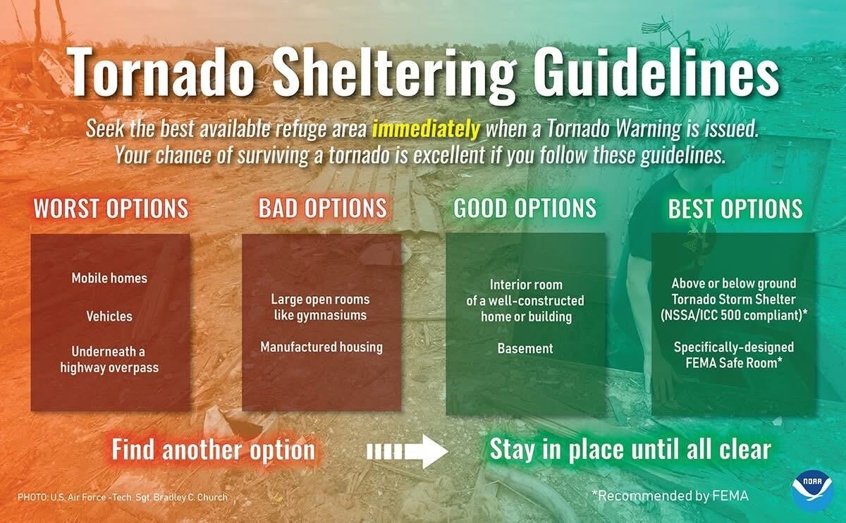
What To Do. Prepare. Clear out your safe space: lowest level, interior room, with as many walls between you and the outside as possible. Place batteries in your NOAA Weather Radio. Charge your phone. Put in your safe space a helmet, shoes, your wallet, and essential medicines. Consider what to do with your pets. Mobile and manufactured home residents should consider another place to sleep. Do all this before you go to bed. Download StormWatch+ for iOS or Android and set it up to wake you up in case of a Tornado Warning. You want a plan in case it wakes you up in the middle of the night. I’ve heard stories from so many of y’all who survived the 3/3/20 tornado who woke up in a daze as debris hit your place. This line will come in as you’re REM sleeping and you may be harder to wake.
What We Hope Changes. We’re hoping models are overdoing the available storm fuels (CAPE) for our two counties. I have a sneaking suspicion fuels will diminish but I have no confidence in my suspicions. We will updating everyone on all our platforms: X, Threads, Instagram, Blue Sky. We go live on YouTube when a warning is issued. We expect this forecast will change a few times. Seek updated information.
LULL (?), THEN ANOTHER BAD ROUND OF SEVERE FOR SATURDAY
Most, not all, models expect a lull in the activity after the sun comes up through around lunch. If there is no lull, the Saturday morning storms may be volatile and dangerous, with all forms of severe weather possible (tornado, hail, straight line winds) including, by Saturday morning, the potential for flooding.
Alert NSWX readers will remember a morning rain being a good thing because it will consume all storm fuels and weaken the afternoon event. That should not happen here. This system is too strong to be destroyed by morning rain.
What. Everything we discussed above — tornado, hail, straight line winds — will be possible Saturday. Same intensities and everything. The key Saturday will be the location of a warm front lifting north from Central Alabama, Northern Alabama, through Middle Tennessee. Ideally for us, if that front will stay south of Williamson County, our severe threat will be reduced but the atmosphere will remain volatile and severe-capable. If the front stretches into Davidson/Williamson Counties, our concern will increase further, along with an enhanced flash flood concern as heavy thunderstorms “train” across our areas.
When. Depends on the lull. While severe will be possible all day, we think the greatest risk for flooding, straight line winds, hail, and tornadoes will be Saturday afternoon and early evening. We think this will all be over sometime between dinner and midnight Saturday night.
What To Do. Same as above. Keep in mind a flooding event may be underway while we see a few rotating supercells, so abandon a low lying or unsafe structure well ahead of any storm arriving. Do not plan to spend your Saturday away from a site built, sturdy structure. Those downtown for the SEC Basketball tournament should remain in the building you find yourself in if a warning is issued: for the love of God don’t try to outrun a tornado. Keep StormWatch+ on and listen to authorities. Stay connected and access your patience reservoirs. Go about your day responsibly.
What We Hope Changes. It’s deffo going to rain and storm. The question is how bad it’ll be. Hoping the warm front gets stuck in Alabama and the higher dewpoints (the oomph in storm fuel) never get here.
BY THE WAY
Alert friends, acquaintances, and enemies in MS and AL that this severe setup will be way worse for them than it looks for us. SPC issued a rare “High Risk” from Jackson MS to Birmingham AL. IMO no one should attempt to return from Spring Break Saturday afternoon up I-65.
FINALLY
My anxiety has been higher before. Not much higher, though. Prepared not scared. We will be with you all the way through it.
 Log In To Facebook To Comment