Summary:
- A Wind Advisory and Flood Watch will go into effect tonight at 7p and go thru 7a Saturday
- Wind gusts up to up to 40 mph will be possible, strongest winds most likely Friday afternoon & evening
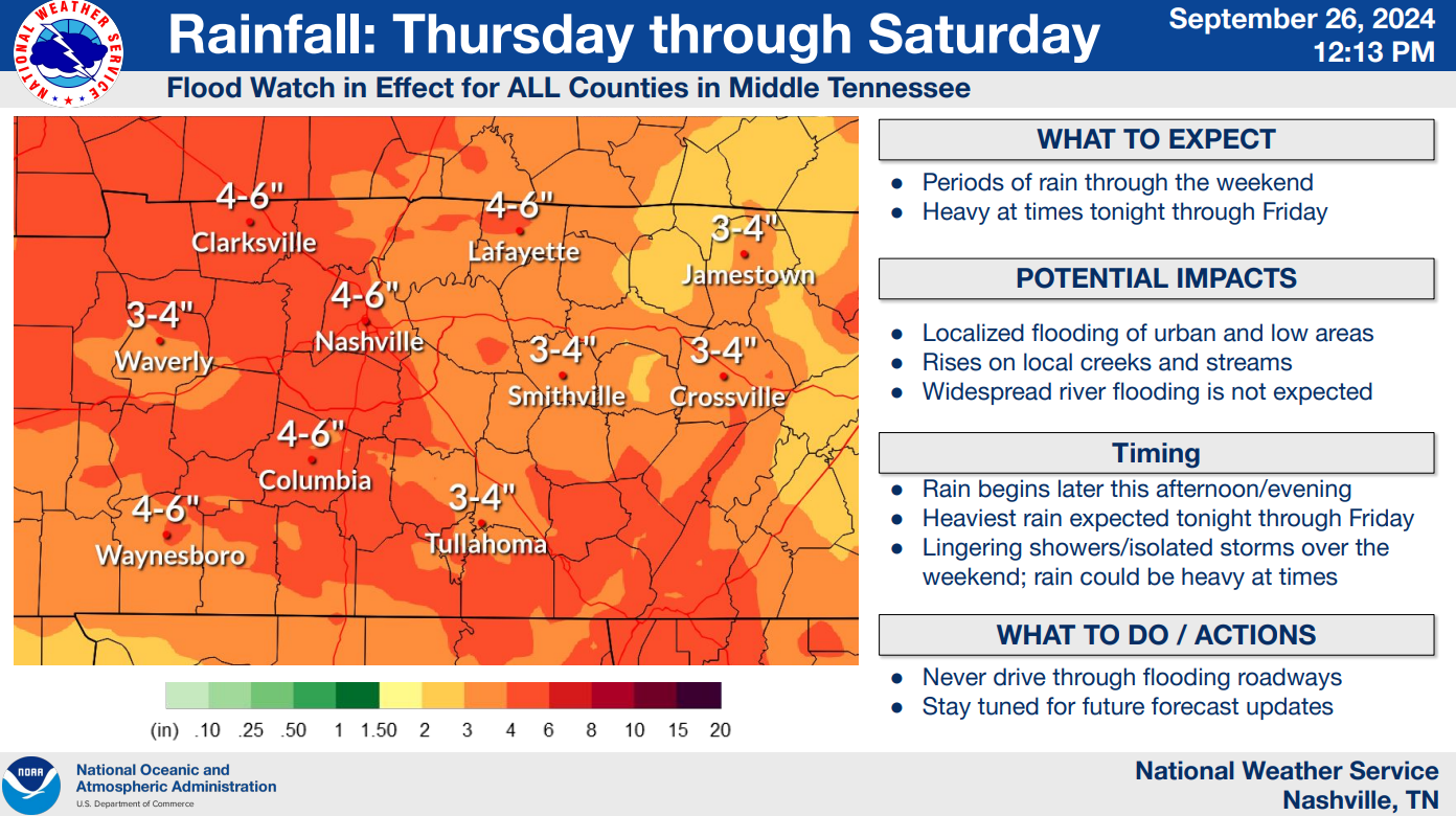
- Rainfall totals from tonight – Saturday, likely in the 2-4″ range – maybe less, maybe more
- Heaviest rain expected tonight – midday Friday, localized flooding possible, no widespread issues expected
- No tornado concerns, lightning unlikely
- We have no clue if your flight will be delayed/canceled
A rough timeline (!that could change!)
- This evening: rain begins, increasing in coverage and intensity
- Overnight tonight: fairly consistent rain, heavy at times
- Friday AM: heavier rain continues, winds will likely start to pick up
- Friday midday: on/off heavy rain continues, 30-40mph wind gusts possible
- Friday evening: the rain begins to lighten up, 30-35mph wind gusts still possible
- Saturday: scattered showers possible throughout the day, winds will let up
Now for the deets.
Latest HRRR model expects rain to begin tonight around 6p, +/- an hour or so.

A steady, consistent rain will continue throughout overnight and continue into Friday.
I’ll let the HRRR model pick back up on Friday morning, showing on/off heavy rain thru Friday afternoon.
Good-ish news for football games, outdoor activities Friday evening/night: this particular run of the HRRR thinks the rain lightens up (but continues) around dinnertime.

Looking at the latest 1hr Euro model, it generally agrees with the HRRR. Rain begins this evening, heaviest rain overnight tonight thru Friday afternoon, with the rain becoming lighter in nature by Friday evening.

Both these models could be off or wrong all together! Be sure to check back in for any updates.
Models agree that lesser rain chances will exist Saturday, and even lower on Sunday – but scattered showers still possible both days.
Expected rainfall totals are expected to be in the 2-4″ range, with some places seeing 4-6″ not out of the question.
No widespread flooding expected, but some localized flooding not out of the question, especially in low-lying areas. As always turn around, don’t drown.

Wind gusts from 30 – 35mph will be common, with gusts 40mph+ not out of the question, especially Friday during the day.
Strong wind could blow down a couple of trees and cause some isolated power outages. Secure outdoor furniture, trampolines, 88lb aunts…

We’ll begin to dry out starting Monday, with dry conditions continuing thru mid next week.
Categories: Featured Blog

