

We’ll be dry until Wednesday evening, when some showers (just rain) move in, shown below by the HRRR model.
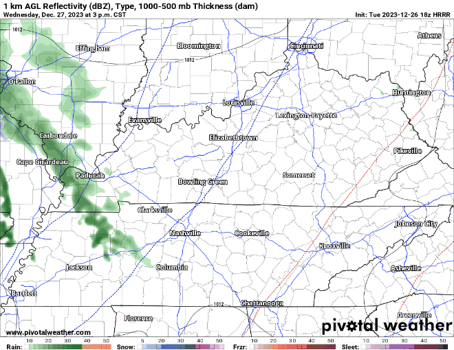
This will just be some light rain. If you look closely, you can see the swirl near the bootheel of MO and southern Illinois, that low pressure system will be the culprit for our snow chances.
If we were to see any snow, our best chances will be Thursday night thru Friday.

The NAM is the only “high-res” model in range for this event for now, it shows scattered snow showers throughout the day Friday, with maybe some rain mixed in. Note: during this time, the NAM keeps temperatures in the 33-35° range, which would make it difficult for snow to accumulate.

This graph above from NWS Nashville shows our probabilities for 0.1″ + of snow, AKA a dusting. Our current probabilities are 30-50%.
Per usual with our snow chances, temperatures will be near the freezing mark. A few degrees either way can make a lot of difference, and models aren’t the best this far out with these sorts of events.
“Models are in good agreement depicting this as a “light” event, with most of Middle Tennessee having just a dusting on grassy areas at best.”
“Sometimes these cold upper level lows can “over-achieve” and a few members of the model ensembles show this with more than 2 inches for high elevations and about 1 inch elsewhere. These higher totals cannot be ruled out where heavier bursts of snow occur, but the borderline temperatures, warm ground, and intermittent nature of the showers will be limiting factors for any meaningful accumulations.”
– NWS Nashville PM AFD
So, best guess right now is maybe a dusting on grassy surfaces, but NWS Nashville notes that the high-end range of the forecast would be around an inch, although this outcome seems unlikely.

Current probabilities of 1″+ of snow are 10-20%. Yeah, yeah…
These probabilities + timing may change (for the better, or worse) over the next few days. We’ll keep you posted. Embracing uncertainty is key.
Saturday and New Year’s Eve look cold and dry, with rain chances returning as we turn the calendar to 2024.

Quick References:
Weather changes constantly.
Follow @NashSevereWx on Twitter for any changes to this forecast.
Live coverage during tornado and severe thunderstorm warnings:

Look good.
Support the mission.

We are 100% community supported. No ads. No subscription fees. Keep it free for everyone.


Categories: Forecast Blogs (Legacy)
You must be logged in to post a comment.